2014
SK5536 : A453, Clifton
taken 10 years ago, near to Wilford, Nottingham, England
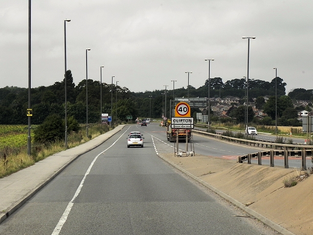
A453, Clifton
The A453, east of the M1, is the major route between Nottingham, the M1 and Nottingham East Midlands Airport. It is one of the most congested roads in the country, carrying up to 30000 vehicles a day. Work on long-awaited major improvements to widen a seven mile stretch of the A453 between M1 Junction 24 and the A52 Nottingham Ring Road started in January 2013. The scheme is scheduled to be completed in summer 2015 and is planned to reduce congestion and make the route safer.
The improvement work includes widening the 1½mile urban section through Clifton from a two-lane single carriageway to a four-lane single carriageway (two lanes in each direction) with signalisation of the existing Crusader Roundabout and new signalised roundabout junctions at Green Lane and Farnborough Road.
A new roundabout at Mill Hill will be sited to the west of the Nottingham City Council and Nottinghamshire County Council boundary, and will provide a connection to the existing A453, Fox Covert Lane and Clifton Lane via a new link road. This road will provide a link to the new Nottingham Express Transit (NET) Park and Ride site, transporting people directly from Clifton into the centre of Nottingham by tram.
Link Nottingham City Council
Link the map of route
See other images of The A453 Widening and Improvement Work
The improvement work includes widening the 1½mile urban section through Clifton from a two-lane single carriageway to a four-lane single carriageway (two lanes in each direction) with signalisation of the existing Crusader Roundabout and new signalised roundabout junctions at Green Lane and Farnborough Road.
A new roundabout at Mill Hill will be sited to the west of the Nottingham City Council and Nottinghamshire County Council boundary, and will provide a connection to the existing A453, Fox Covert Lane and Clifton Lane via a new link road. This road will provide a link to the new Nottingham Express Transit (NET) Park and Ride site, transporting people directly from Clifton into the centre of Nottingham by tram.
Link
Link
See other images of The A453 Widening and Improvement Work
 Map © Crown Copyright")
TIP: Click the map for more Large scale mapping
- Grid Square
- SK5536, 96 images (more nearby 🔍)
- Photographer
- David Dixon (more nearby)
- Date Taken
- Friday, 8 August, 2014 (more nearby)
- Submitted
- Sunday, 2 November, 2014
- Subject Location
-
OSGB36:
 SK 558 360 [100m precision]
WGS84: 52:55.1220N 1:10.2219W - Camera Location
-
OSGB36: SK 559 360
- View Direction
- Southwest (about 225 degrees)