SP8822 : Wing - All Saints - Saxon Crypt from southern doorway
taken 10 years ago, near to Wing, Buckinghamshire, England
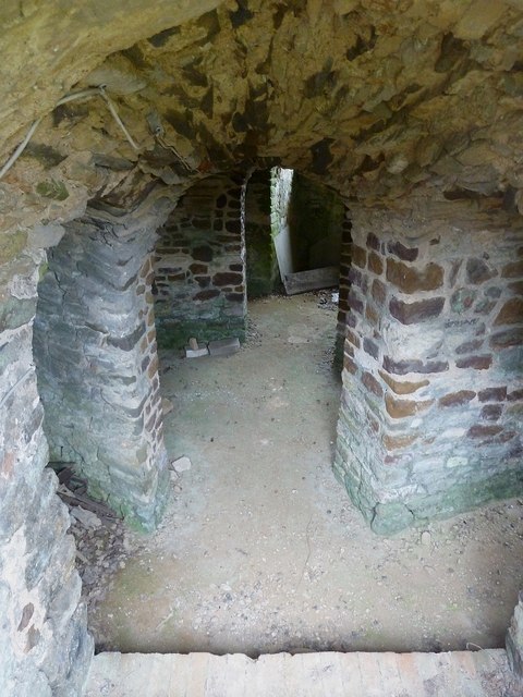
The top of this doorway and the railings can be seen in SP8822 : Wing - All Saints - Saxon polygonal apse
More views into the crypt here SP8822 : Saxon Crypt, All Saints, Wing and SP8822 : Wing - All Saints - Saxon Crypt from eastern arch
The church of All Saints in Wing dates back to the 9th century, and much of the surviving structure is of Saxon origin. This makes it one of the oldest extant buildings in Britain.
The oldest part of this remarkable church is the crypt beneath the slightly later apsidal chancel. According to Pevsner (Buildings of England:Buckinghamshire) this crypt is probably of the C9th. The EH (Grade I) listing Linkstates of the church "Originally C10 with nave, N. aisle, chancel and crypt surviving from this period. Probably built for Aelfgifa, sister-in-law to King Eadgar."
North and South Aisles were added (or remodelled) in the C14th and C15th, though the north wall of the North Aisle is also of Saxon origin. The Tower and South Porch were added in the C15th, and a North Porch added in more modern times (Victorian probably). There is a helpful plan of the church here Link
See also the VCH write-up here Link
The Church of England's own page about the church can be seen here Link
Parish website Link
Note there is a separate Shared Description for the fonts themselves Link
This is a photo-linking snippet about the churches that house them.
Note: The number of these fonts is reckoned as either 22 or 23 as the example at Wing retains only its base.
The following 23 churches contain "Aylesbury" fonts - though the final one (at Wing) retains only its base.
Aylesbury, Bucks - St Mary's - C13th - EH Grade I Link
Barton-le-Clay, Beds - St Nicholas - C12th-15th - EH Grade I Link
Bledlow, Bucks - Holy Trinity - C12th-13th - EH Grade I Link
Information and photos of the church (local parish website) Link
Buckland, Bucks - All Saints - C13th-16th - EH Grade II* Link
Chearsley, Bucks - St Nicholas - C12th-13th - EH Grade II* Link
Chenies, Bucks - St Michael - C15th - EH Grade I Link
Dinton, Bucks - SS Peter & Paul - C12th-15th - EH Grade I Link
Duston, Nhants - St Luke - C12th-14th - EH Grade I Link
Eydon, Nhants - St Nicholas - C13th-14th - EH Grade II* Link
Flitwick, Beds - SS Peter & Paul - C12th,14th & 16th - EH Grade I Link
Great Hampden, Bucks - St Mary Magdalen - C13th-15th - EH Grade II* Link
Adjacent to magnificent Hampden House ( Grade I Link
Great Kimble, Bucks - St Nicholas - C13th-14th - EH Grade I Link
Great Missenden, Bucks - SS Peter & Paul - C14th - EH Grade I Link
Haddenham, Bucks - St Mary the Virgin - C12th-13th - EH Grade I Link
Houghton Regis, Beds - All Saints - C14th - EH Grade I Link
Little Missenden - St John the Baptist - C10th-14th (Saxon core) - EH Grade I Link
Ludgershall - St Mary the Virgin - C14-15th - EH Grade I Link
Monks Risborough - St Dunstans - C14th-15th - EH Grade I Link
Old Linslade, Beds* - St Mary's - C12th,14th&15th (Norman core) - EH Grade I Link
Pitstone - St Mary the Virgin - C13th - EH Grade I Link
Saunderton - SS Mary & Nicholas - C19th after C12th-14th church destroyed by fire. - EH Grade II* Link
Weston Turville - St Mary the Virgin - C13th-15th - EH Grade I Link
Wing - All Saints - (Only base remains) - C10th - EH Grade I Link
*(Old Linslade used to be in Bucks)
 Map © Crown Copyright")
- Grid Square
- SP8822, 184 images (more nearby 🔍)
- Photographer
- Rob Farrow (more nearby)
- Date Taken
- Thursday, 11 September, 2014 (more nearby)
- Submitted
- Thursday, 13 November, 2014
- Subject Location
-
OSGB36:
 SP 8804 2258 [10m precision]
WGS84: 51:53.6896N 0:43.3187W - Camera Location
-
OSGB36: SP 8804 2257
- View Direction
- North-northwest (about 337 degrees)