2014
SJ8097 : Manchester Ship Canal, Lowry Bridge
taken 9 years ago, near to Trafford Park, Trafford, England
This is 1 of 4 images, with title starting with Manchester Ship Canal, Lowry in this square
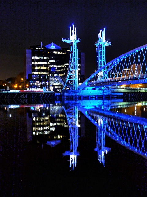
Manchester Ship Canal, Lowry Bridge
Also known Millennium Bridge (it was built in 2000) the Lowry Bridge provides pedestrian access between The Lowry Centre on the north bank of the Manchester Ship Canal and Trafford Wharf on the south bank. It was designed as a lift bridge because the Manchester Ship Canal is still navigable to shipping beyond the bridge (Link - Manchester History Net). This view is from Salford Quays, looking towards Trafford Wharf.
At night, the apperarance of the bridge is enhanced by a sequence of coloured lighting. Compare this view with SJ8097 : Lowry (Millennium) Bridge, taken 80 seconds earlier.
At night, the apperarance of the bridge is enhanced by a sequence of coloured lighting. Compare this view with SJ8097 : Lowry (Millennium) Bridge, taken 80 seconds earlier.
See other images of Lowry Bridge
See other images of Salford Quays and MediaCityUK
 Map © Crown Copyright")
TIP: Click the map for more Large scale mapping
- Grid Square
- SJ8097, 1166 images (more nearby 🔍)
- Photographer
- David Dixon (more nearby)
- Date Taken
- Monday, 8 December, 2014 (more nearby)
- Submitted
- Friday, 12 December, 2014
- Subject Location
-
OSGB36:
 SJ 804 970 [100m precision]
WGS84: 53:28.1676N 2:17.7495W - Camera Location
-
OSGB36: SJ 805 970
- View Direction
- Southwest (about 225 degrees)