2015
NY9166 : Warden Cross, Church of St Michael, Warden
taken 9 years ago, near to Warden, Northumberland, England
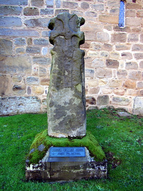
Warden Cross, Church of St Michael, Warden
The cross is located in the churchyard about 3m south of the church tower. Formerly thought to be a Saxon stone cross, now recognised as being a reused Roman altar converted to a Saxon grave slab. The figure on the surface is crudely executed and its depiction uncertain. The hammerhead cross in relief is also crudely executed. It formerly stood in the garden of Nether Warden House and was placed in present position in the churchyard, in the angle of the tower and the south porch, in 1957. The cross has been erected on a stone base bearing a small plaque inscribed: 'Warden Village Cross - Early 7th Century'
This type of cross was seen after the battle of Heavenfield (633/634) and was used as a focal point for preaching and praying before churches were built.
Grade I Listed (1155434): Link Archive Link
Pastscape: Link Archive Link
This type of cross was seen after the battle of Heavenfield (633/634) and was used as a focal point for preaching and praying before churches were built.
Grade I Listed (1155434): Link
Pastscape: Link
 Map © Crown Copyright")
TIP: Click the map for more Large scale mapping
- Grid Square
- NY9166, 198 images (more nearby 🔍)
- Photographer
- Andrew Curtis (more nearby)
- Date Taken
- Saturday, 10 January, 2015 (more nearby)
- Submitted
- Saturday, 10 January, 2015
- Subject Location
-
OSGB36:
 NY 9135 6648 [10m precision]
WGS84: 54:59.5697N 2:8.2036W - Camera Location
-
OSGB36: NY 9135 6647
- View Direction
- NORTH (about 0 degrees)