SJ8990 : St Peter's Stained Glass (3 of 5)
taken 9 years ago, near to Stockport, England
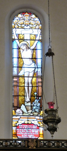
It carries the wording "These windows were placed here to the glory of God and as an affectionate memorial of the Revd Henry Wright and Mary Catherine his wife by their daughter Julia Catherine Wright 1889."
Best viewed in the larger sizes.
St Peter's Church was built as a chapel at ease, at the behest of William Wright, in red brick with slate roof and round-headed windows to the nave. The west tower rises to an octagonal belfry with clock face. The chancel was added in 1888.
William Wright was Lord of the Manor of Offerton and Mottram St Andrew. His town house in Stockport was the Mansion House on High Street and St Petersgate was constructed by him as a convenient route between his house and his church.
It was consecrated on 31st May 1768 by Bishop Edmund Keene. In 1861 St Peter's became an "Ecclesiastical District", only becoming a fully fledged Parish in 1968. In 1985 the Parish became a United Benefice with St Thomas.
The church clock, built in 1769 by John Whitehurst, is the oldest public clock in Greater Manchester. The mechanism is on view in the church having been restored to working order in 1985.
High up in the belfry is a bell cast at the Rudhall Foundry in Gloucester and inscribed "Prosperity to this town T.R. 1768".
Church website: Link
 Map © Crown Copyright")
- Grid Square
- SJ8990, 2240 images (more nearby 🔍)
- Photographer
- Gerald England (more nearby)
- Date Taken
- Thursday, 8 January, 2015 (more nearby)
- Submitted
- Monday, 12 January, 2015
- Subject Location
-
OSGB36:
 SJ 8948 9030 [10m precision]
WGS84: 53:24.5644N 2:9.5831W - Camera Location
-
OSGB36: SJ 8947 9029
- View Direction
- EAST (about 90 degrees)