2015
SK9771 : An Expansive Place Baron
taken 9 years ago, near to Lincoln, Lincolnshire, England
This is 1 of 3 images, with title An Expansive Place Baron in this square
An Expansive Place Baron
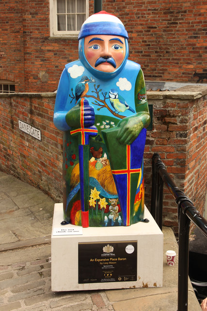
Lincoln Barons' Charter Trail sculpture at the meeting of Danesgate and Steep Hill, painted by Lizzy Mason, representing Richard de Percy Link (Archive Link )
Richard de Percy was a member of the powerful Percy family from the north of England. He joined the revolt against King John after Magna Carta and had all his lands confiscated, but he got them all back after making peace with King Henry III after the death of King John. He died in 1244 and was buried in Whitby Abbey.
Richard de Percy was a member of the powerful Percy family from the north of England. He joined the revolt against King John after Magna Carta and had all his lands confiscated, but he got them all back after making peace with King Henry III after the death of King John. He died in 1244 and was buried in Whitby Abbey.
Lincoln Barons' Charter Trail
800 years ago in June 1215, Magna Carta was sealed by King John in the presence of 25 Barons at Runnymede and Lincoln has one of four copies of The Great Charter. As part of the 800th anniversary celebrations, the Lincoln Barons Charter Trail Link
 Map © Crown Copyright")
TIP: Click the map for more Large scale mapping
- Grid Square
- SK9771, 4977 images (more nearby 🔍)
- Photographer
- Richard Croft (more nearby)
- Date Taken
- Monday, 15 June, 2015 (more nearby)
- Submitted
- Saturday, 20 June, 2015
- Subject Location
-
OSGB36:
 SK 9765 7165 [10m precision]
WGS84: 53:13.9751N 0:32.3104W - Camera Location
-
OSGB36: SK 9765 7166
- View Direction
- SOUTH (about 180 degrees)