TQ5838 : 66, The Pantiles
taken 9 years ago, near to Royal Tunbridge Wells, Kent, England
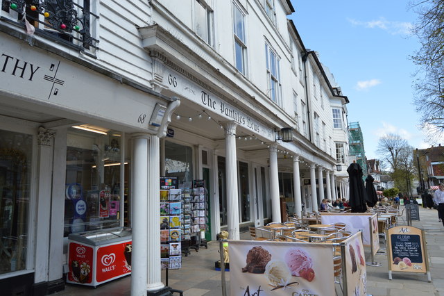
The Pantiles is the most famous street in Tunbridge Wells. It was originally a grove of trees until the Chalybeate spring was discovered in 1606. It rapidly developed into the hub of the new spa town. The street has over 40 listed buildings on it.
The Pantiles and Tunbridge Wells itself, owe their beginnings to the discovery of the Chalybeate Spring in the early 17th century and the popularity of the spa water amongst the gentry and royalty of Georgian England. As Tunbridge Wells grew in popularity as a spa resort, so did the area surrounding the Spring - eventually leading to the building of the colonnaded walkway in the 18th century, later known as The Pantiles.
In its heyday in Georgian times, the 'Walks' as they were then known, were the place to see and be seen for visitors to Tunbridge Wells. A strict protocol was adhered to - gentry on the 'Upper Walks', the colonnade, and everyone else on the 'Lower Walks'. Richard Beau Nash, a dandy of the day made it his business to ensure that this protocol was adhered to by acting as a kind of Master of Ceremonies during 'the season' in Tunbridge Wells and in the town's rival, Bath. Things are much more relaxed nowadays and the Pantiles is now a very attractive and stylish part of Royal Tunbridge Wells.
Much of the colonnade has been renewed since its beginnings in the 17th century but most of the surrounding buildings date from the 18th and 19th centuries.
The tiled surface is Grade II listed. Link
 Map © Crown Copyright")
- Grid Square
- TQ5838, 2001 images (more nearby 🔍)
- Photographer
- N Chadwick (more nearby)
- Date Taken
- Saturday, 18 April, 2015 (more nearby)
- Submitted
- Thursday, 9 July, 2015
- Subject Location
-
OSGB36:
 TQ 5803 3867 [10m precision]
WGS84: 51:7.5310N 0:15.4135E - Camera Location
-
OSGB36: TQ 5803 3867
- View Direction
- North-northwest (about 337 degrees)