SD8964 : Pennine Way, Watlowes Dry Valley
taken 9 years ago, near to Malham, North Yorkshire, England
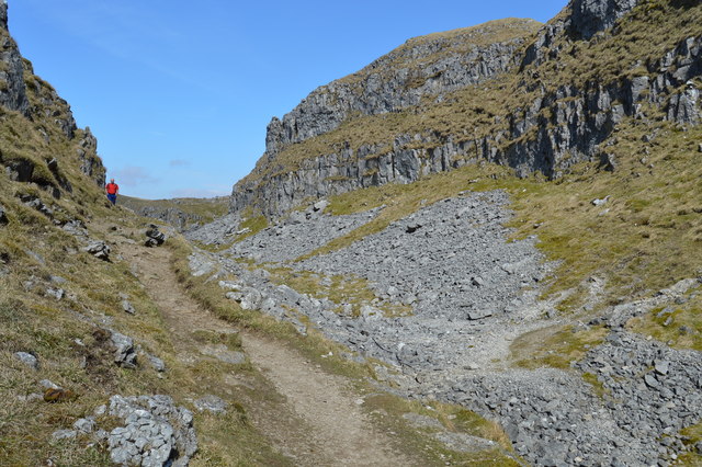
Below the Water Sinks, and above Malham Cove lies a deep limestone canyon which is known as the Dry Valley, or Watlowes Valley. Whatever underground route the streams of Malham Moor may now take, Watlowes Valley was almost certainly carved out by the glacial overspill from Malham Tarn flowing to what was once England's highest waterfall at Malham Cove. Now the valley is dry, and contains some most impressive limestone features, with plenty of exposed and weathered rock.
The Pennine Way long distance footpath leads up the dry valley and on to the Water Sinks.
The Pennine Way is a National Trail in England, with a small section in Scotland. The trail runs 267 miles from Edale, in the northern Derbyshire Peak District, north through the Yorkshire Dales and the Northumberland National Park and ends at Kirk Yetholm, just inside the Scottish border. The path runs along the Pennine hills, sometimes described as the "backbone of England". Although not the United Kingdom's longest National Trail, it is according to the Ramblers' Association "one of Britain's best known and toughest".
 Map © Crown Copyright")
- Grid Square
- SD8964, 525 images (more nearby 🔍)
- Photographer
- N Chadwick (more nearby)
- Date Taken
- Tuesday, 7 April, 2015 (more nearby)
- Submitted
- Friday, 17 July, 2015
- Subject Location
-
OSGB36:
 SD 8921 6490 [10m precision]
WGS84: 54:4.7943N 2:9.9848W - Camera Location
-
OSGB36: SD 8921 6486
- View Direction
- NORTH (about 0 degrees)