2015
TG1141 : Weybourne Station, North Norfolk Railway
taken 9 years ago, near to Weybourne, Norfolk, England
This is 1 of 4 images, with title Weybourne Station, North Norfolk Railway in this square
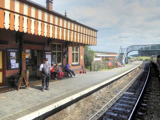
Weybourne Station, North Norfolk Railway
Weybourne is an attractive, well-preserved rural station on the North Norfolk Railway. It is located over a mile from the village of Weybourne and is actually closer to Weybourne Heath. Midland and Great Northern Joint Railway had not originally intended it to be the site of a station; it was opened later than most of the line.
The main station was built in 1900 although other structures, of the appropriate era, such as the signal box, waiting room and footbridge have been 'imported' from other locations. BR levelled the station (apart from the main station building) and track on the closure of the line).
Weybourne train station is sometimes used for filming and on-screen TV appearances. Perhaps its main claim to fame is as the location of Walmington-on-Sea railway station in the Dad's Army episode "The Royal Train", and as Crimpton-on-Sea railway station in the BBC TV sitcom Hi-De-Hi!
Link North Norfolk Railway
The main station was built in 1900 although other structures, of the appropriate era, such as the signal box, waiting room and footbridge have been 'imported' from other locations. BR levelled the station (apart from the main station building) and track on the closure of the line).
Weybourne train station is sometimes used for filming and on-screen TV appearances. Perhaps its main claim to fame is as the location of Walmington-on-Sea railway station in the Dad's Army episode "The Royal Train", and as Crimpton-on-Sea railway station in the BBC TV sitcom Hi-De-Hi!
Link
The North Norfolk Railway (Poppy Line) :: TG1543
The North Norfolk Railway (NNR), also known as the "Poppy Line", is a heritage steam railway. The line, which once formed part of the Midland and Great Northern Joint Railway, is just over 5 miles long and runs between the coastal town of Sheringham and the terminus at Holt. There are two stops between Sheringham and Holt, Weybourne and Kelling Heath. The original line opened in 1887 and closed in 1964; work on rebuilding the line started in 1965, and on 4 June 1967, two steam locomotives were delivered.
The NNR operates both steam and diesel-hauled services, and organises a programme of seasonal special events.
Link
 Map © Crown Copyright")
TIP: Click the map for more Large scale mapping
- Grid Square
- TG1141, 380 images (more nearby 🔍)
- Photographer
- David Dixon (more nearby)
- Date Taken
- Monday, 3 August, 2015 (more nearby)
- Submitted
- Tuesday, 11 August, 2015
- Subject Location
-
OSGB36:
 TG 118 419 [100m precision]
WGS84: 52:55.9674N 1:8.9998E - Camera Location
-
OSGB36: TG 117 419
- View Direction
- East-northeast (about 67 degrees)