2015
SN7553 : Cwm Doethie byway erosion, Ceredigion
taken 9 years ago, near to Ty'n-y-Cornel [other Features], Ceredigion, Great Britain
This is 1 of 4 images, with title Cwm Doethie byway erosion, Ceredigion in this square
Cwm Doethie byway erosion, Ceredigion
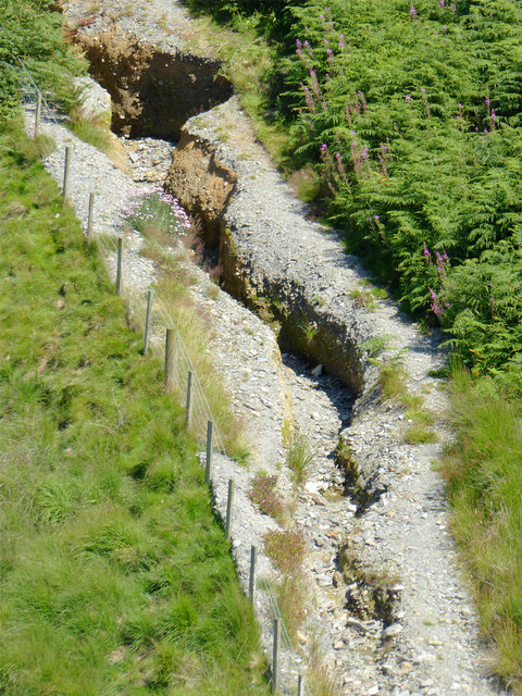
An aerial view of the damage to the former drover's road where it climbs above the Doethie Fach bridge, seen with telephoto assistance from the lower slopes of Gouallt. The gully is more than two metres deep in some places.
Context image: SN7553 : Drovers' road climbing from Cwm Doethie, Ceredigion
SN7553 : Cwm Doethie byway erosion, Ceredigion
SN7553 : Cwm Doethie byway destroyed, Ceredigion
Context image: SN7553 : Drovers' road climbing from Cwm Doethie, Ceredigion
SN7553 : Cwm Doethie byway erosion, Ceredigion
SN7553 : Cwm Doethie byway destroyed, Ceredigion
 Map © Crown Copyright")
TIP: Click the map for more Large scale mapping
- Grid Square
- SN7553, 345 images (more nearby 🔍)
- Photographer
- Roger D Kidd (more nearby)
- Date Taken
- Tuesday, 18 August, 2015 (more nearby)
- Submitted
- Monday, 24 August, 2015
- Subject Location
-
OSGB36:
 SN 7565 5333 [10m precision]
WGS84: 52:9.8513N 3:49.1667W - Camera Location
-
OSGB36: SN 7542 5326
- View Direction
- East-northeast (about 67 degrees)