ST2952 : Church of Saint Mary, Berrow: Statuette
taken 9 years ago, near to Berrow, Somerset, England
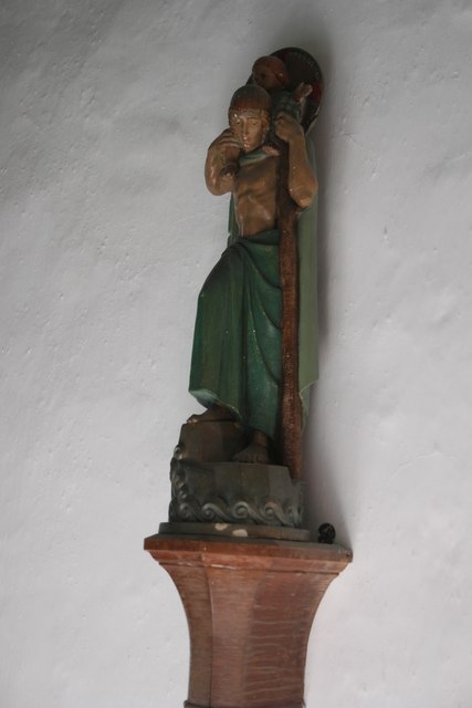
There is a Saint Christopher's Way, and a more recent Saint Christopher's School, in nearby Burnham. The church in Burnham is dedicated to Saint Andrew, and I am not sure what the connection of either place with Saint Christopher might be. This statue is not mentioned in the church guide book nor the historic guide on the notice board.
Dedicated to the Virgin Mary this church is sometimes called 'The Church in the Dunes'. The original 10th century village it used to serve is buried in the nearby dunes, and the church has occasionally had to be rescued from the same fate.
The dunes are man-made. Following the Tsunami of 1607 which caused so much damage locally Marram grass was planted to encourage the formation of dunes to protect Berrow Parish. Nearby Burnham was a busy port, and did not take the same precautions. Berrow's dunes have pushed the coastline back nearly a Km from the original line, and the church is surrounded by sandhills.
The first church on this spot was recorded in 1020, but no trace of that survives. The substantial church of 1100 is represented only by the base of the current chancel arch. The current nave dates from 1280, and a notice in the church dates the south aisle and the tower to the 15th century.
There was once a minstrel's gallery in the west end of the church, and a carved beam, known as 'the Jacobean Beam', from that gallery hangs above the main door in the south aisle.
A tabernacle cross, or preaching cross, stood outside the church. The iconoclasts of the Reformation destroyed it, but the head was concealed in the wall of the church where it was rediscovered in 1926 and is now on show next to the altar. This cross is separately listed as a historic monument.
As well as the cross and the church itself, Historic England lists three other features associated with the church: two memorials in the churchyard, and the remains of two effigies just outside the porch. The effigies must originally been inside the church, but are badly eroded and the figures depicted are unknown.
The peal of 6 bells is not regularly rung.
The chancel roof dates from 1974, as does the organ at the back of the nave. There is also an electrical piano which is now used in preference to the new organ.
In 2019 the box pews were removed in favour of movable chairs, and the erstwhile step at the main door was replaced with a sloping floor. The whole interior was redecorated and the heating pipes in the nave boxed in, giving the whole space a clean and open aspect.
St Mary's is the parish church, and busy and well attended.
The church is a grade I listed building Link
The base of the former preaching cross is a separate grade II listing Link
The other churchyard features listed are LinkLink
See Link
See Link
See Link
See Link
 Map © Crown Copyright")
- Grid Square
- ST2952, 132 images (more nearby 🔍)
- Photographer
- Bob Harvey (more nearby)
- Date Taken
- Wednesday, 26 August, 2015 (more nearby)
- Submitted
- Saturday, 29 August, 2015
- Subject Location
-
OSGB36:
 ST 293 524 [100m precision]
WGS84: 51:16.0086N 3:0.8160W - Camera Location
-
OSGB36: ST 293 524
- View Direction
- Southeast (about 135 degrees)