TQ4210 : Church of St Thomas a Becket
taken 9 years ago, near to Lewes, East Sussex, England
Grade II* listed
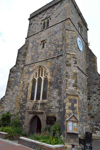
Most of the church is 14th century, with a 15th century tower, although there was a previous Chapel of ease in the 12th century in the village of cliff. The church had at least one aisle in the 13th century. Like many churches it has undergone several alterations over the years
The church consists of a 3 stage western tower, nave with north and south aisles, chancel and vestry.
The chancel contains remnants of the original Norman Chapel. There is a double squint near the pulpit. This could be for lepers to observe the mass or for an assistant priest to raise the Host at the same time as the priest at the main altar.
The nave has three Bay north and south aisles. There are various paintings hung on the walls.
The church was reconstructed in the 14th century - the roof timbers date from then, and the tower which is built of flint and stone is from the 15th century. The weathervane is dated 1756. The tower clock was made in 1670.
The aisles may have been raised at some time, and they had galleries inserted; both aisles had galleries by the 18th century.
The church was restored in 1877, although some work may have been done previously, especially to the windows. The galleries were removed in 1884 and the vestry was built in the 19th century and extended in 1930.
The organ was first installed in 1740, and another organ in 1802. The present organ is the successor to it.
Outside the church there is a public pump which was erected in 1804, but moved in 1903 to its present position.
Listed buildings and structures are officially designated as being of special architectural, historical or cultural significance. There are over half a million listed structures in the United Kingdom, covered by around 375,000 listings.
Listed status is more commonly associated with buildings or groups of buildings, however it can cover many other structures, including bridges, headstones, steps, ponds, monuments, walls, phone boxes, wrecks, parks, and heritage sites, and in more recent times a road crossing (Abbey Road) and graffiti art (Banksy 'Spy-booth') have been included.
In England and Wales there are three main listing designations;
Grade I (2.5%) - exceptional interest, sometimes considered to be internationally important.
Grade II* (5.5%) - particularly important buildings of more than special interest.
Grade II (92%) - nationally important and of special interest.
There are also locally listed structures (at the discretion of local authorities) using A, B and C designations.
In Scotland three classifications are also used but the criteria are different. There are around 47,500 Listed buildings.
Category A (8%)- generally equivalent to Grade I and II* in England and Wales
Category B (51%)- this appears generally to cover the ground of Grade II, recognising national importance.
Category C (41%)- buildings of local importance, probably with some overlap with English Grade II.
In Northern Ireland the criteria are similar to Scotland, but the classifications are:
Grade A (2.3%)
Grade B+ (4.7%)
Grade B (93%)
Read more at Wikipedia Link
 Map © Crown Copyright")
- Grid Square
- TQ4210, 386 images (more nearby 🔍)
- Photographer
- N Chadwick (more nearby)
- Date Taken
- Sunday, 12 July, 2015 (more nearby)
- Submitted
- Wednesday, 23 December, 2015
- Subject Location
-
OSGB36:
 TQ 4213 1026 [10m precision]
WGS84: 50:52.4622N 0:1.1236E - Camera Location
-
OSGB36: TQ 4213 1026
- View Direction
- North-northwest (about 337 degrees)