NS4276 : The former site of Hill of Garshake Farm
taken 8 years ago, near to Bellsmyre, West Dunbartonshire, Scotland
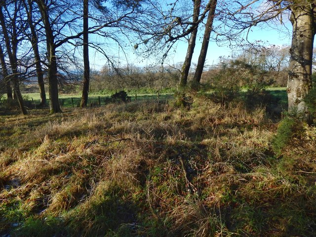
At the centre of the present image is a mound. By most standards, it is inconspicuous, but I could discern that there were rectangular footings beneath it. This is a view from the south-east; for a view from the south-west, which is on the left in this image, see NS4276 : The former site of Hill of Garshake Farm.
As explained in the first end-note (click on the title of that end-note for related pictures), the farm had been abandoned before the first-edition OS map of the area was surveyed in 1860. It is therefore not named on that map, although its ruin is shown, as well as the track leading to it. After about 1914, its ruin was no longer sufficiently distinct for it to be shown on maps; at present, it is not indicated on OS maps at any scale.
The name of the farm is supplied, instead, by Roy's Military Survey of Scotland, which shows "Upper Garsheake" at a point roughly between the still-extant Maryland Farm (see NS4176 : Track to Maryland Farm) and NS4276 : Garshake Farm (called "Garsheake" on Roy's map). The name Upper Garshake, however, seems to be peculiar to Roy's map.
In historical records (see the notes at the end of this item), a farm called Hill is several times mentioned in connection with Garshake Farm. Occasionally, it is mentioned by itself, without reference to Garshake, and it is then referred to as Hill of Garshake, perhaps because the name Hill, without further context to clarify it, did not seem sufficiently distinctive. Hill of Garshake supplied one of Dumbarton's burgesses: James MacIntyre, who was admitted a Burgess and Guild Brother on January 8th 1757.
It seems that "Hill" or "Hill of Garshake" is the same as the "Upper Garshake" that appears on Roy's Map; there was no other likely candidate in the area. In what follows, I will treat these names as equivalent.
John Ainslie's 1821 map of the southern part of Scotland shows "Hill of Garshake", but not plain "Garshake". Garshake Farm certainly existed at that time, but one possibility is that Ainslie omitted it for reasons of space: in that part of his map, the place-names are tightly packed together.
A few months before submitting this picture, I had come across a cultivated plot Link higher up on the moor, alongside an ancient track: NS4277 : Ancient track and cultivated plot. I would not expect to encounter a plot of this kind anywhere other than beside farm buildings. Also, the ancient track itself makes a conspicuous change of direction in the vicinity of the plot, as though something substantial, such as an existing farmstead, had made a more direct route impossible; there is nothing in the topography of the moor itself that would have made the less direct route necessary or even desirable. I therefore suspected at first that this plot might have been the site of Upper Garshake Farm (no traces of buildings are visible there, but plots, dykes, and enclosures often remain visible for longer than do small farm buildings beside them). However, when I submitted a report about the cultivated plot to WoSAS (West of Scotland Archaeology Service), the helpful contact there pointed out to me a ruin that is marked on the first-edition map, namely, the one whose site is shown in the present picture; he suggested that this was the probable location of Upper Garshake.
I entirely agree with his assessment. For one thing, Roy's map shows Upper Garshake's position in relation to still-extant nearby farms, and to nearby burns: the site shown in this picture corresponds very well to the position of Upper Garshake, as indicated by that map; in contrast, the site of the cultivated plot does not match. Also, although I believe that there was a farmstead beside that plot, the absence of any visible traces of buildings there strongly suggests that any farmstead there disappeared far too early for it to be the one that is shown as Hill of Garshake on Ainslie's 1821 map, and as Upper Garshake on Roy's map of c.1740s-50s.
The plot and its associated farm buildings (if there were any) belong to a still earlier period. The NS4277 : Remains of an ancient farmhouse, not far to the north-east, are perhaps of a comparable age; they likewise appear to pre-date Roy's map. There, too, the remains of enclosures are far more visible than those of the small farmhouse that once stood beside them.
- - - -
As already mentioned, an ancient track (see Link for a detailed discussion), passes the cultivated plot. The course of that track can be followed south-westwards across the moor, although its course is covered first by gorse and then by trees: for two parts of that track, as seen when heading progressively south-west from the plot, see NS4277 : Ancient track and NS4276 : Braided track in woodland. (That track was just one of a network of old tracks; the second of the end-notes to this item is about that network.)
The track can be followed as far as NS4276 : The edge of the woods at NS42067681. Beyond that point, modern agriculture has greatly changed the landscape: the enclosure and ploughing of fields, the cultivation of crops, and the planting of trees will have removed any clear evidence of the track's continuation. Nevertheless, if the ancient track maintained its south-westerly course, as is likely, it would have led up to the site of Upper Garshake Farm, shown here, and then continued in the same direction. The strip of woodland in which the ruin is now located did not then exist, but is useful as a reference: the former course of the ancient track probably ran just inside, and parallel to, what is now the north-western edge of that strip of woodland.
From NS41667643, the track would probably have run to NS41437609, though not necessarily by the line of the present-day road (NS4176 : Garshake Water Works) through the old waterworks: if its course was more direct, it may have run a little to the east of that road. From there, the route most probably met up with and continued down the line of present-day Garshake Road (NS4175 : Garshake Road). Of course, the line of the track, after it leaves the moor, can only be conjecture (unless old estate plans or future archaeological investigations shed light on it), but the route described above is a plausible one.
Whatever the course of the track in this area was, the aforementioned agricultural changes would have necessitated some changes, and the first-edition OS map sheds light on these, even though the farm itself had already been abandoned by the time the first-edition map was surveyed in 1860. It is clear from the map that after the planting of the strip of woodland in which the ruin is now located, access to Upper Garshake Farm was by means of a track that followed the south-eastern side of those woods. That track is still marked on the 1:25000 map at present, although its appearance shows that it has long been disused: NS4276 : Disused track.
The track led north-east, through NS41967666, along the edge of the woods, to about the point shown in NS4276 : Disused track. A short branch of the track led north-west from there, leading to the front (the south-west) side of the farmhouse. That short part of the track, cutting SE-NW across the strip of woodland, can still be discerned as a clearing: NS4276 : The former site of Hill of Garshake Farm.
As shown on the present-day 1:25000 map, the main part of that farm track continued north-east along the south-eastern side of the strip of woodland, to the point shown in NS4276 : Disused track. It would therefore have provided access to NS4276 : The edge of the woods, and so to the moor beyond, from Upper Garshake Farm and from the still-extant Garshake Farm.
The field shown in the background of the present picture is the one shown in NS4276 : View of field from corner.
NOTES:
A very early mention of Hill in connection with Garshake can be found in the Register of the Great Seal (RMS): charter #190 in Volume 8, by James VI, and dated 13 December 1609, mentions Hill along with Garshake and other still recognisable local place-names:
▪ "Corslat, Stanyflatt, Aikenbar, Chapeltoun, Guisholme, Glen, Murvaich, Auchinreoch, Kilmalid, Milnerosmedow, Rudreding, Mariland, Hedriward, Gartshaik, Howetshaw, Hill, Lonyngheid alias Braidbank, Rounredding".
[In modern spelling, the other places named in that passage include the still-extant farms Murroch and Maryland; Stoneyflat, Howatshaws and Aitkenbar (now gone, but commemorated by street names in Bellsmyre); Crosslet, Gooseholm and Kilmalid, names that are still in use; Roundriding (Road), doubtless connected with the "Barundridain" that is shown on the 1654 Pont/Blaeu map of the Lennox; and Loaninghead (now gone, but shown on the first-edition OS map of 1860).
The names are separated in that list, though only by a single entry. However, the close connection between Hill and Garshake is made more explicit in other records from a few decades later: given below are some examples, from the published "Dumbarton Common Good Accounts 1614-1660", of records where Hill is mentioned in connection with Garshake.]
▪ The first example is from the records of 1659-60; the two records, which are consecutive, pertain to increases in feu duty:
"Item for the augmentation of the few dewty of the landes of Garshaike 00 04 00"
"Item for the augmentation of the few dewty of the landes of Hill 00 02 00"
▪ The second example is from a Stent Roll of 1643 (given in Appendix A of the cited work); in this case, the entries are not merely consecutive, but are in fact linked:
"The Laird of Luss for his landis of Garschaik occupyit be John Smelie 20 00 00"
"and for his landis of Hill 05 00 00"
▪ Lastly, a Teinds Valuation of 1656 (given in Appendix F of the cited work) has an entry for Hill, immediately followed by one for Garshake. The entries themselves merely specify certain quantities of meal (oatmeal) and bear (barley-meal), and are not worth reproducing here.
Of the four times that "Hill" is mentioned in that book, three of the occurrences, described above, are immediately beside an entry for Garshake. It is therefore likely that the unqualified name "Hill" refers to the farm that is elsewhere referred to as "Hill of Garshake", and which is marked as "Upper Garshake" on Roy's map.
"Hill of Garshake" (simply called "Hill" where context prevented ambiguity) is mentioned in various old records. It appears to be the same place as the "Upper Garshake" shown on Roy's Military Survey of Scotland (1740s-50s); it was abandoned before the first OS maps of the area were made, and is not named on OS maps of any period. Its ruin is shown but not named on the first-edition map (surveyed in 1860), and on subsequent maps up until c.1914. Thereafter, its ruins had become too faint for them to be included on maps. See Link for further discussion, and for its position in relation to an ancient track.
A very extensive network of ancient tracks on the moors in West Dunbartonshire links old quarries, ruined lime-kilns, and other sites connected with the local limestone-burning industry, which flourished in the 18th century. See Link for a Geograph article about the network, and Link
for an annotated satellite view of it.
 Map © Crown Copyright")
- Grid Square
- NS4276, 215 images (more nearby 🔍)
- Photographer
- Lairich Rig (more nearby)
- Date Taken
- Friday, 15 January, 2016 (more nearby)
- Submitted
- Tuesday, 2 February, 2016
- Subject Location
-
OSGB36:
 NS 4201 7676 [10m precision]
WGS84: 55:57.4678N 4:31.9350W - Camera Location
-
OSGB36: NS 4201 7675
- View Direction
- Northwest (about 315 degrees)