SK8707 : Church of St Edmund, Egleton
taken 8 years ago, near to Egleton, Rutland, England
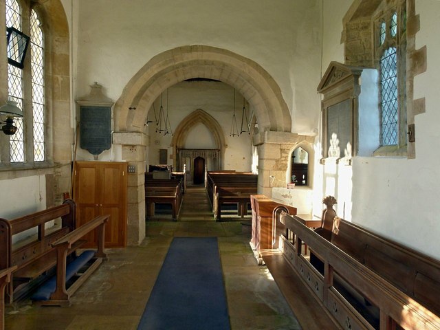
The church consists of nave and chancel with south porch and west tower.
The oldest parts are the south and east walls of the nave, dating from the 12th century. The most evident surviving work of this period are the chancel arch and the south doorway. The 14th century saw the addition of a north aisle, but this was removed at an unspecified date and the arcade walled up, although it is still very clear both internally and externally. The outer doorway of the porch is of this time, although the porch was rebuilt much later. The chancel was added in the 15th century, when the large windows in the south wall were also inserted. The tower was rebuilt in the 18th century, apparently following a fire, when the spire was added.
Internally the fine Norman chancel arch immediately takes the eye. Of the same period is the square font. Medieval timberwork includes the chancel screen, now moved to the west end of the nave, and a few poppyhead pew ends. There is a much faded Royal Hatchment painted on the plaster above the chancel arch. Other fittings are 19th century or later.
The church is Listed Grade I. Information is taken from the church's own leaflet and the Victoria County History. Link
Listed buildings and structures are officially designated as being of special architectural, historical or cultural significance. There are over half a million listed structures in the United Kingdom, covered by around 375,000 listings.
Listed status is more commonly associated with buildings or groups of buildings, however it can cover many other structures, including bridges, headstones, steps, ponds, monuments, walls, phone boxes, wrecks, parks, and heritage sites, and in more recent times a road crossing (Abbey Road) and graffiti art (Banksy 'Spy-booth') have been included.
In England and Wales there are three main listing designations;
Grade I (2.5%) - exceptional interest, sometimes considered to be internationally important.
Grade II* (5.5%) - particularly important buildings of more than special interest.
Grade II (92%) - nationally important and of special interest.
There are also locally listed structures (at the discretion of local authorities) using A, B and C designations.
In Scotland three classifications are also used but the criteria are different. There are around 47,500 Listed buildings.
Category A (8%)- generally equivalent to Grade I and II* in England and Wales
Category B (51%)- this appears generally to cover the ground of Grade II, recognising national importance.
Category C (41%)- buildings of local importance, probably with some overlap with English Grade II.
In Northern Ireland the criteria are similar to Scotland, but the classifications are:
Grade A (2.3%)
Grade B+ (4.7%)
Grade B (93%)
Read more at Wikipedia Link
 Map © Crown Copyright")
- Grid Square
- SK8707, 190 images (more nearby 🔍)
- Photographer
- Alan Murray-Rust (more nearby)
- Date Taken
- Tuesday, 9 February, 2016 (more nearby)
- Submitted
- Saturday, 13 February, 2016
- Subject Location
-
OSGB36:
 SK 8760 0753 [10m precision]
WGS84: 52:39.5056N 0:42.3798W - Camera Location
-
OSGB36: SK 8760 0753
- View Direction
- WEST (about 270 degrees)