NS4377 : Old and new boundaries
taken 8 years ago, 3 km from Milton, West Dunbartonshire, Scotland
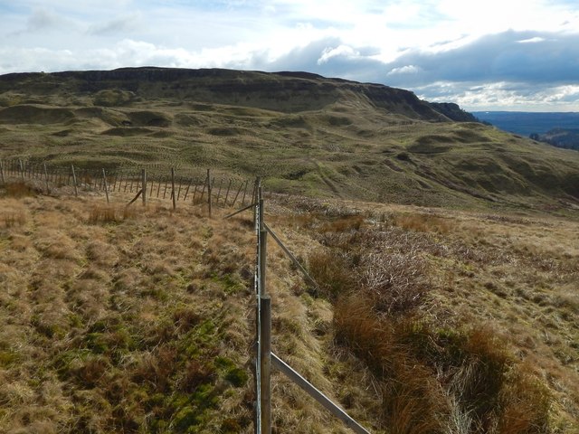
The nearer portion of the fence, leading up to the corner, more or less corresponds to the line of that ancient boundary.
As the 1:25000 map shows, that boundary almost lines up, but not quite, with another boundary to the south, on the other side of the Overtoun Burn. That other boundary is similar in appearance, and is shown in NS4377 : Old boundary and NS4377 : Old boundary, and, conveniently highlighted by a light covering of snow, in NS4377 : Remains of old boundary.
It can also be seen in the present picture as a line snaking up the front of the Long Crags, to the right of the corner of the deer fence.
The boundary to the north of the Overtoun Burn heads towards the centre of the Black Craig. The boundary to the south of the Overtoun Burn heads towards the western end of the Black Craig, but, as marked on the 1:25000 map, it stops short, at the burn.
It is possible that the more northerly boundary once continued a little further, to the Overtoun Burn, but that the traces have been lost from the steep slope there. This is very speculative, though (see NS4377 : Old boundary for more on that topic).
At the time of writing (2017), there seem to be no entries about these linear mounds in online archaeology databases.
My own observations are that the banks are not simply overgrown dry-stone dykes: they are much older. As will be explained below, the sequence from older to more recent is: (1) these field banks; (2) ancient braided tracks that cross the same area; and (3) the dry-stone walls marked on the first-edition OS map (c.1860).
The field banks are predominantly earthen, but they contain many large rounded boulders (NS4377 : Old boundary), many of them made of red sandstone of a kind that can be found in the area around NS435774, as also revealed by the prominent red colouration of the soil in the modern-day paths there.
(The most similar field bank I have encountered is one that crosses Cochno Hill, about 56 km to the ESE: for that feature, see NS4875 : Remains of a boundary and related links for further information.)
Note, in connection with the following description of the field banks at Overtoun, that their course is represented on the current 1:25000 OS map:
The ancient field bank leaves the edge of the Kilpatrick Hills at NS43567720, heading NNW for 140 metres, to NS43507733. At that point it forks: one branch heads north-west, and a present-day path cuts through it at NS43407740. The other branch is longer, and heads almost northwards towards the Overtoun Burn opposite Black Craig (a prominent rock outcrop; see Link for details).
On the other side of the burn, at NS43457768, above the centre of Black Craig, the boundary reappears, not quite on the same line, but displaced about 60 metres further to the east. From the top of Black Craig it heads NNW, gently curving to the left, so that it is heading WNW by the time it crosses the line of a modern fence at NS43177799.
This part of the boundary, north of the Overtoun Burn, is twice crossed by ancient braided tracks, at NS433877855 and NS43107801. At the second of these points, the field bank has already become indistinct (NS4377 : Old boundary it peters out at about this point), but it is clearly visible at the first crossing.
The braided tracks are themselves centuries old, and have links to the local limestone industry (see Link for more information and for many more pictures). However, the field bank is older: the braided track cuts notches (shown in NS4377 : Old boundary) through the bank where the two meet.
More recent than either are the dry-stone walls marked on the first-edition OS map (c.1860). Where they meet, the dry-stone wall is simply built on top of the field bank, as would be expected. Where the dry-stone wall and the braided tracks meet, there are no gaps in the walls (NS4377 : Dry-stone wall); the tracks, though deep from long use, had been abandoned by the time those walls were built.
 Map © Crown Copyright")
- Grid Square
- NS4377, 146 images (more nearby 🔍)
- Photographer
- Lairich Rig (more nearby)
- Date Taken
- Friday, 4 March, 2016 (more nearby)
- Submitted
- Monday, 21 March, 2016
- Subject Location
-
OSGB36:
 NS 4342 7774 [10m precision]
WGS84: 55:58.0233N 4:30.6155W - Camera Location
-
OSGB36: NS 4342 7775
- View Direction
- SOUTH (about 180 degrees)