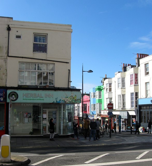
TQ3004 : 83, Western Road, Brighton
taken 8 years ago, near to Brighton and Hove, England
Old Images
Number 83 in 1895 - Link
Number 83 in 1910 - Link
1845-1846 - LINEN DRAPER (Thomas Clark)
1848-1879 - CHEMIST (G Chantler 1848, JA Tabrum 1850-52, William Smith 1854-79)
1880 - CHINA & GLASS MERCHANT (J Haines)
1883-1950 - LADIES OUTFITTERS (Hetheringtons)
1951-1973 - SHOE SHOP (Charles H Baber Ltd 1951-62, Norvic Foot Fitters 1964-73)
1974 - GOWNS (Pamela)
1978-1989 - TRAVEL (British Airways)
1990-2004 - PHOTOGRAPHIC PROCESSORS (Snappy Snaps (1990-91, Colorama 1993-2004)
2006-2016 - ACUPUNCTURIST (Herbal Inn)
The main shopping street of Brighton that runs west from the junction with North Street reaches the old boundary with Hove at the junction with Little Western Street then continues on to Palmeira Square. On the eastern side is the main shopping area of the town, Churchill Square whose construction necessitated the removal of numbers 1-28 in the 1960s. As the road heads west the large multi-national and national chain stores give way to smaller or more local services. Beyond Montpelier Road up to the Hove boundary a large number of eateries can be found. The buildings themselves can be divided between those on the southern side and those to north. The former are small single occupancy buildings, sometimes expanded into the neighbouring property, largely from the 19th century with one or two exceptions; numbers 52-55 were rebuilt in 1903, 61-62 in the 1920s, 79-80 and 86 also date from the same decade and were specifically designed for banks. The northern side has been entirely rebuilt during the 1920s and 1930s from Hampton Place to North Street and contain a series of department stores, some now subdivided. These have been unaltered with the exception of 175-180 which was rebuilt after a serious fire in the 1970s.
The road actually predates the growth of Brighton originally being a track that ran across open fields to Hove church. Development began in the early 19th century initially at the eastern end and was clustered around terraces; Regents Place, Clarence Place and Western Place whose gardens backed onto the track. By the 1830s these disparate groups of terraces had been renamed Western Road after the family of the same name who originally owned much of the land in the vicinity and resided at Preston Manor. An impetus to development was the construction of Brunswick Town which was erected next to the road on the Hove side. Another was the villas, terraces and crescents in the Montpelier and Clifton estates to the north. The through access nature of the road meant that it now began to convert to commercial use with many of the former gardens being built over or extended into causing a narrowing of the street. By the mid 19th century much of Western Road was commercial with only small pockets of residential buildings to the west of Montpelier Road and these too would convert towards the end of that century. The last residential house to go was West Hill Lodge on the north eastern corner of Montpelier Road which was demolished in 1905.
The extension of the shop fronts particularly on the northern side narrowed the road considerably and was causing problems even in the age of the horse and cart. Consequently, the council began long term planning for widening the road beginning in 1905 when the gardens of houses west of Montpelier Road and those belonging to Codrington Place. From 1926 to 1938 all the blocks east to North Street were redeveloped pushing the road line back and largely giving the layout the street retains today. Many of the new buildings, with the exception of Mitre House, were built in the prevailing fashion as department stores and a number still operate as a single occupancy today, with 195-200, purpose built for Marks & Spencer in 1932 still inhabiting the building today. The last major building works occurred in the late 1960s on the southern side when a large block was removed for construction of the open area in front of Churchill Square.
The construction of the shopping centre in the 1960s and its rebuilding in the late 1990s both caused an influx of businesses into the centre and there was much worry during the latter refurbishment when Debenhams left its old premises lessening the reason to walk down to the western end of the road. Whilst Waitrose on the opposite side has remained and even expanded into neighbouring properties providing some anchor to the street you can still detect a change of business type beyond Argos which has only gradually begun to creep westwards again now the shops of Mitre House have been filled.
 Map © Crown Copyright")
- Grid Square
- TQ3004, 1737 images (more nearby 🔍)
- Photographer
- Simon Carey (more nearby)
- Date Taken
- Friday, 25 March, 2016 (more nearby)
- Submitted
- Tuesday, 29 March, 2016
- Subject Location
-
OSGB36:
 TQ 3036 0439 [10m precision]
WGS84: 50:49.4630N 0:9.0331W - Camera Location
-
OSGB36: TQ 3038 0441
- View Direction
- Southwest (about 225 degrees)