SP9499 : Wakerley ironstone quarries
taken 8 years ago, near to Barrowden, Rutland, England
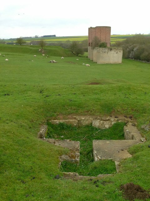
The ironstone workings at Wakerley were neither very extensive, nor long-lived, but the result of this is that there has been less perceived need to restore the site with the result that there is a more complete set of remains than at most of the regions quarry locations.
The remains include a prominent quarry gullet, the largely complete trackbed of the railway/tramway connecting the workings to the mainline railway and of course the prominent calcining kilns.
The site shows evidence of two tramways., leading to raised tipping docks. The western of the two is the earlier, operated by Bell & Co between 1913 and early 1914. In early 1915the lease was taken up by the Wakerley Ironstone Co. Ltd., and the easterly tramway probably dates from their commencement of operations in 1916, although this is unconfirmed. The company was taken over by the Partington Steel and Iron Co in 1918.
The most spectacular consequence of this take-over was the erection of four calcining kilns, evidence of an expectation of substantial workings. They were built partly on the site of the original tipping dock, the embankment to which has been cut back. The purpose of calcining the ore is to reduce bulk by driving off moisture and CO2 from the limestone element of the ore, thus reducing its bulk and as a result transport costs. This is a relatively labour intensive process however. In practice only two of the four kilns were built up from their bases, and even these were never put into operation. They are now all Listed Grade II.
The new tramway had its own tipping dock, the masonry face of which survives in quite good condition. It was clearly built in two stages, as the original portion is in stone and the later of brick. On top of the embankment to this dock are a set of stone foundations which almost certainly belonged to a weighbridge.
In the event, the geological conditions of the ore deposits, particularly those north of the road between Wakerley and Harringworth, were found unsuitable for mechanised quarrying and operations are thought to have ceased in 1921. Today the area is largely given over to sheep pasturing, with the result that the earthworks are largely undisturbed and not subject to significant erosion.
For full details of the quarries, see this publication: The Ironstone Quarries of the Midlands Part 6, E.Tonks, 2009 edition by Book Law Publications, pp.263-9. ISBN 978-1-907094-05-7
 Map © Crown Copyright")
- Grid Square
- SP9499, 108 images (more nearby 🔍)
- Photographer
- Alan Murray-Rust (more nearby)
- Date Taken
- Monday, 4 April, 2016 (more nearby)
- Submitted
- Saturday, 9 April, 2016
- Subject Location
-
OSGB36:
 SP 9484 9964 [10m precision]
WGS84: 52:35.1782N 0:36.0952W - Camera Location
-
OSGB36: SP 9484 9964
- View Direction
- WEST (about 270 degrees)