SK9401 : Church of St Mary the Virgin, South Luffenham
taken 8 years ago, near to South Luffenham, Rutland, England
The church comprises an aisled nave with chancel, this having a chapel on the south side, west tower with spire and south porch.
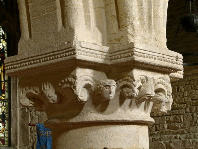
It originated as a typical 12th century aisleless church with chancel. No trace of this remains, the earliest fabric being the arcade to the north aisle which was added c.1190-1200. This shows a mix of Norman and Transitional work. A south aisle was added in the first half of the 13th century in Early English style.
In the 14th century the church was completely remodelled, largely assuming the current layout. Both aisles were rebuilt, the south aisle being extended east, and a clerestory. The rebuilding also saw the addition of the tower and spire, and the south porch. The final medieval work in the 15th century included the raising of the chancel roof and insertion of new windows.
The tower is of three stages, with a single large opening in Decorated style in each face of the upper, bell chamber stage, topped with a battlemented parapet. This topped by a relatively narrow octagonal spire with crocketted ribs and three tiers of lucarnes in alternating faces.
There was an extensive refurbishment in 1861 under the direction of the eminent Victorian church architect, G E Street, but the only significant alteration was the insertion of a new east window in Decorated style.
Internally the main fitments of note are a 14th century table tomb in the chancel, a 14th century font, and an ancient oak parish chest. At the chancel arch are the remains of a 15th century rood screen, much cut down.
The church is Listed Grade II*. For a fuller description, see the Victoria County History of Rutland Link
 Map © Crown Copyright")
- Grid Square
- SK9401, 76 images (more nearby 🔍)
- Photographer
- Alan Murray-Rust (more nearby)
- Date Taken
- Monday, 11 April, 2016 (more nearby)
- Submitted
- Saturday, 16 April, 2016
- Subject Location
-
OSGB36:
 SK 9412 0190 [10m precision]
WGS84: 52:36.4043N 0:36.6941W - Camera Location
-
OSGB36: SK 9412 0190
- View Direction
- North-northeast (about 22 degrees)