2016
SN0406 : Cresswell Quay
taken 8 years ago, near to Cresswell Quay, Pembrokeshire/Sir Benfro, Wales
This is 1 of 3 images, with title Cresswell Quay in this square
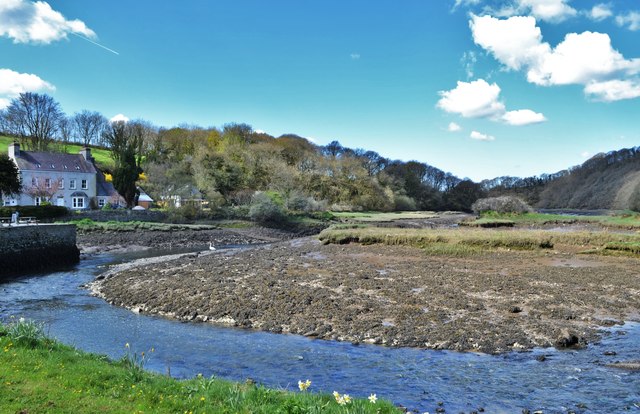
Cresswell Quay
The coal industry was intimately associated with the quay at Cresswell and has been crucial in defining the present landscape of the area. Coal has been mined in this area since the late medieval period. Between 1768 and 1828 over 50 small pits were operating inland from the quay. Several of these pits are shown on Carew Mountain and Whitehill on a 1777 estate map. Coal was loaded onto barges at Cresswell and shipped down-river to Lawrenny where it was loaded onto larger ships. Coal folds were constructed at the quay to store coal prior to shipping. By the 1820s the industry was in decline, although the last commercial use of the quay was in 1948 when a load of culm was landed from Hook. Houses and cottages built for and by workers in the industry produced a distinctive settlement pattern and vernacular architecture, and a village developed at the quayside. New settlements emerged at Pisgah, around a nonconformist chapel, and at Whitehill. A map of 1848 of Tenements on Carew Mountain suggests that at least part of this settlement pattern was the result of miners constructing cottages on common land. This may also account for the field system of small regular plots on the mountain and at Whitehill.
 Map © Crown Copyright")
TIP: Click the map for more Large scale mapping
- Grid Square
- SN0406, 39 images (more nearby 🔍)
- Photographer
- Deborah Tilley (more nearby)
- Date Taken
- Saturday, 23 April, 2016 (more nearby)
- Submitted
- Sunday, 24 April, 2016
- Subject Location
-
OSGB36:
 SN 0497 0668 [10m precision]
WGS84: 51:43.4899N 4:49.5128W - Camera Location
-
OSGB36: SN 0499 0669
- View Direction
- West-southwest (about 247 degrees)