SN9767 : Red Kite Feeding Signs on the A470 at Rhayader
taken 8 years ago, near to Rhayader/Rhaeadr Gwy, Powys, Wales
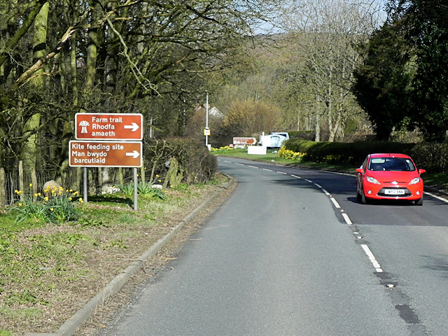
Gigrin Farm Red Kite Feeding and Rehabilitation Centre, near Rhayader is one kite feeding location where between 200 and 500 kites visit per day. It is signposted by brown (tourist route) signs on the A470 into the town from the south.
The A470, also known as the Cardiff to Glan Conwy Trunk Road, is the major long-distance road in Wales, from Cardiff on the south coast to Llandudno on the north coast. It is 185 miles long, and has undergone considerable road improvement in the last two decades. While previously one had to navigate the narrow roads of Llanidloes and Dolgellau, both these market towns are now bypassed due to extensive road modernisation.
The road travels through two of Wales's national parks, the Brecon Beacons in the South and Snowdonia National Park, starting just south of Dinas Mawddwy in the North. It is a primary trunk route throughout its length, and the southernmost 26 miles, from Cardiff Bay to Merthyr Tydfil, is mainly direct and good quality dual carriageway, but most of the route from north of Merthyr to Llandudno is single carriageway.
LinkSABRE
 Map © Crown Copyright")
- Grid Square
- SN9767, 86 images (more nearby 🔍)
- Photographer
- David Dixon (more nearby)
- Date Taken
- Wednesday, 13 April, 2016 (more nearby)
- Submitted
- Wednesday, 15 June, 2016
- Subject Location
-
OSGB36:
 SN 977 676 [100m precision]
WGS84: 52:17.8187N 3:30.0474W - Camera Location
-
OSGB36: SN 978 675
- View Direction
- West-northwest (about 292 degrees)