2016
NO4630 : Broughty Castle
taken 8 years ago, near to Broughty Ferry, Dundee, Scotland
This is 1 of 33 images, with title Broughty Castle in this square
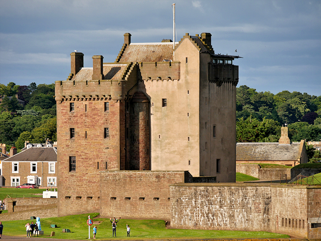
Broughty Castle
Broughty Castle stands on a rocky promontory on the banks of the River Tay near Dundee. It was completed ca1495, although the site had been fortified earlier the fifteenth century. The castle faced many sieges and battles during the next two centuries but began to fall into disrepair after it was sold in 1661.
In 1846 the castle was bought by the Edinburgh and Northern Railway Company in order to build the adjacent harbour for their railway ferry. In 1855 the castle was acquired by the War Office and in 1860 renewed fears of a French invasion led to the site being rebuilt and fortified the site. From 1886 to 1887 a range was built to house submarine miners to the east of the castle. In an emergency these would lay mines in the Tay Estuary to damage enemy shipping. In 18891891 a magazine was built within the western enclosure which also led to a major remodelling of the gun emplacements.
The castle remained in military use until 1932, and again between 1939 and 1949. The last defence-related alteration was made in the Second World War when a defence post was built within the top of the main tower. In 1969 the castle opened as a museum operated by Dundee city council (Link Broughty Castle Museum).
The castle is a scheduled monument (SM90043 Link Historic Scotland).
In 1846 the castle was bought by the Edinburgh and Northern Railway Company in order to build the adjacent harbour for their railway ferry. In 1855 the castle was acquired by the War Office and in 1860 renewed fears of a French invasion led to the site being rebuilt and fortified the site. From 1886 to 1887 a range was built to house submarine miners to the east of the castle. In an emergency these would lay mines in the Tay Estuary to damage enemy shipping. In 18891891 a magazine was built within the western enclosure which also led to a major remodelling of the gun emplacements.
The castle remained in military use until 1932, and again between 1939 and 1949. The last defence-related alteration was made in the Second World War when a defence post was built within the top of the main tower. In 1969 the castle opened as a museum operated by Dundee city council (Link
The castle is a scheduled monument (SM90043 Link
 Map © Crown Copyright")
TIP: Click the map for more Large scale mapping
- Grid Square
- NO4630, 288 images (more nearby 🔍)
- Photographer
- David Dixon (more nearby)
- Date Taken
- Friday, 8 July, 2016 (more nearby)
- Submitted
- Friday, 19 August, 2016
- Subject Location
-
OSGB36:
 NO 464 304 [100m precision]
WGS84: 56:27.7666N 2:52.2176W - Camera Location
-
OSGB36: NO 464 301
- View Direction
- NORTH (about 0 degrees)