TF1722 : River Glen
taken 8 years ago, near to Guthram Gowt, Lincolnshire, England
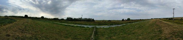
The Glen is embanked above the fen all the way from Kates Bridge on the A15 to the sluice at Surfleet where it joins the Welland.
If the power lines look as though they are arching upwards, they aren't. There was a strong easterly blowing which produced ripples on the river that gave the illusion it was flowing the wrong way.
Using land purchased in 2009 the Lincolnshire Wildlife Trust is seeking to recreate the original undrained wetland of the fens.
The reserve lies to the south of the River Glen, and is crossed along that boundary by the Macmillan way national trail. It is nearly continuous with the Pinchbeck Slipe and Baston Fen reserves, making a continual natural habitat from the A15 to Pinchbeck Bar. The Souther Edge is the pair of drains that form the Counter Drain, and the western end is marked by the old railway bridge that once took the Bourne to Spalding railway across that drain.
There is a small car park at the entrance, but it is possible to drive right through the reserve to the banks of the River Glen, where there is disabled parking and access to a proper visitor centre. Be warned that Counter Drain Road (the method of access to the southern side) is one of the bumpiest in the whole of Lincolnshire.
The official web site is at Linkand there is another at Link
A 290 mile route devised to raise funds for Macmillan Cancer Support to which all proceeds are donated. It runs along sea banks and river banks, from Boston, across the Lincolnshire fens via Stamford, eventually to Abbotsbury on the Dorset Coast. From the fens it follows, as near as possible, the course of the oolitic limestone belt, called 'Cotswold' stone in that area, but found in slightly varying form from South Yorkshire to Dorset.
The Way provides a link with the Viking Way at Oakham, the Thames Path National Trail near Thames Head and with the South West Coast Path National Trail at the finish. It also has a Macmillan Way West (Link ) from Castle Cary to Barnstaple.
The River Glen is a tributary of the River Welland. It flows entirely through Lincolnshire, except a short stretch near Essendine in Rutland. Wikipedia: Link
 Map © Crown Copyright")
- Grid Square
- TF1722, 47 images (more nearby 🔍)
- Photographer
- Bob Harvey (more nearby)
- Date Taken
- Thursday, 18 August, 2016 (more nearby)
- Submitted
- Monday, 29 August, 2016
- Subject Location
-
OSGB36:
 TF 173 225 [100m precision]
WGS84: 52:47.2453N 0:15.7073W - Camera Location
-
OSGB36: TF 173 225
- View Direction
- West-northwest (about 292 degrees)