2016
SE3039 : Saint John's Church, Harrogate Road, Moor Allerton, Leeds
taken 8 years ago, near to Chapel Allerton, Leeds, England
This is 1 of 13 images, with title Saint John's Church, Harrogate Road, Moor Allerton, Leeds in this square
Saint John's Church, Harrogate Road, Moor Allerton, Leeds
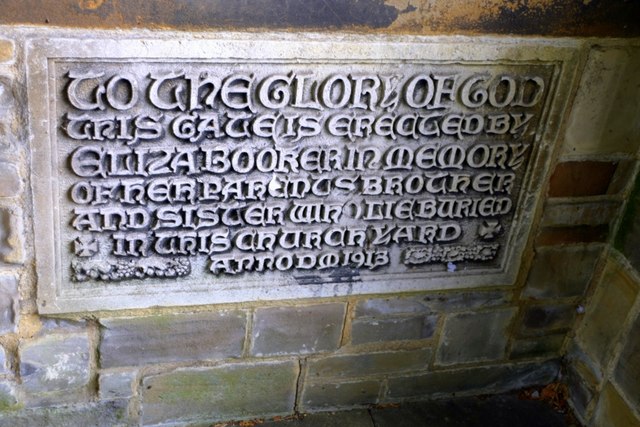
St.Johns Moor Allerton was built in 1853. A clock was installed by Potts of Leeds in 1862.
In 1889, with a growing local population, 2 vestries were added, the chancel enlarged, 2 transepts were provided and the churchyard was levelled and drained. In 1987 further re-arrangements were made: a second entrance was provided (by way of the north transept) the pulpit was replaced and the chancel steps were extended. Some pews were removed to give more flexibility to worship. The original building plans were prepared by Joseph Thompson in his office in the Leeds central market buildings and it was built by George Nettleton of Roundhay. Weetwood white sandstone was used for the interior with the exterior built from the Potternewton Quarry. Major donors included the Earl of Harewood and George Lane Fox of Bramham Park. The Church was consecrated on December 13th 1853 by Dr.Longley, the Bishop of Ripon together with Dr. Hook, Vicar of Leeds.
See other images of Saint John's Church, Harrogate Road, Moor Allerton, Leeds
 Map © Crown Copyright")
TIP: Click the map for more Large scale mapping
- Grid Square
- SE3039, 150 images (more nearby 🔍)
- Photographer
- Mark Stevenson (more nearby)
- Date Taken
- Thursday, 1 September, 2016 (more nearby)
- Submitted
- Thursday, 1 September, 2016
- Subject Location
-
OSGB36:
 SE 3071 3926 [10m precision]
WGS84: 53:50.9205N 1:32.0812W - Camera Location
-
OSGB36: SE 3072 3926
- View Direction
- Southwest (about 225 degrees)