2016
J3474 : City Quays, Belfast (September 2016)
taken 8 years ago, near to Belfast, Co Antrim, Northern Ireland
City Quays, Belfast (September 2016)
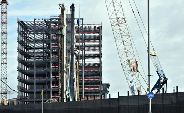
CQ2s structural steelwork (left) and the hotel site, marked by the drill and crane, seen from the roadside at Donegall Quay.
On 8 July 2016 Belfast Harbour Commissioners issued an information memorandum for a Design Contest for design, construction and installation of piece of artwork . . . . . BHC is procuring the design and build of a piece of public art to be located in a pedestrianised square in the City Quays Development. The piece of art will be placed proximate to the entrance of a 9-story 4 star hotel to be constructed in City Quays . . . It is envisaged that the art solution will be no higher than 14 metres and may act as a geographical point of reference/meeting signpost in the area.
On 8 July 2016 Belfast Harbour Commissioners issued an information memorandum for a Design Contest for design, construction and installation of piece of artwork . . . . . BHC is procuring the design and build of a piece of public art to be located in a pedestrianised square in the City Quays Development. The piece of art will be placed proximate to the entrance of a 9-story 4 star hotel to be constructed in City Quays . . . It is envisaged that the art solution will be no higher than 14 metres and may act as a geographical point of reference/meeting signpost in the area.
City Quays, Belfast
A large-scale redevelopment of an area of disused harbour land (including the former Donegall Quay ferry terminal), on the seaward side of the cross-harbour bridges.
It includes three office buildings, a hotel and a multi-storey car park.
The third office building (CQ3) received planning permission on 5 February 2019 City Quays 3 - erection of 16 storey office accommodation (74 metres maximum height) comprising 23,976 sq metres of gross floorspace, associated access, public realm and other ancillary development. Lands approximately 100m north of M3 Cross Harbour Bridge and bounded by the River Lagan to the east Donegall Quay and Clarendon Dock to the north Corporation Square and Clarendon Quay to the west.
Loading map... (JavaScript required)
- Grid Square
- J3474, 4349 images (more nearby 🔍)
- Photographer
- Albert Bridge (more nearby)
- Date Taken
- Friday, 2 September, 2016 (more nearby)
- Submitted
- Friday, 2 September, 2016
- Subject Location
-
Irish:
 J 344 748 [100m precision]
WGS84: 54:36.2450N 5:55.2545W - Camera Location
-
Irish: J 343 747
- View Direction
- North-northeast (about 22 degrees)