TF0920 : Bourne institutions
taken 8 years ago, near to Bourne, Lincolnshire, England
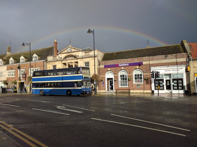
Fleet number 160 AD51DLD was bought in September 2015 from Dublin Corporation
This is one of the few remaining family-run businesses still running a traditional local bus service. These disappeared either through the general decline in bus usage or from competition following deregulation and privatisation in the mid 1980s.
The main service has always been between Bourne and Peterborough via the Deepings. For many years an hourly frequency was operated, but with the expansion of housing, particularly in the Deepings, and improvements to the road network in Peterborough which allowed shorter journey times, there are currently (2018) two journeys an hour between Bourne and Peterborough, one of which extends to Morton. An additional hourly journey operates between the Deepings and Peterborough. The fact that the majority of the fleet are double-deck buses is an indication that levels of patronage are still high. Current fares levels are very competitive with the cost of parking in the centre of Peterborough.
Unlike many other small operators, Delaine Buses have not relied on second-hand buses no longer in the prime of condition, but have pursued a policy of purchasing new vehicles whenever possible. Once bought, the fleet has always been maintained to high standards. A good example of this is that not only are the most recent vehicles fitted with CCTV (now a normal part of the specification of any new buses), but older buses have been retrofitted too.
A trip on the top of a Delaine bus covers a variety of landscapes including the modern new-town development of Peterborough, the wide-open fenland landscape and the attractive stone-built towns and villages of south Lincolnshire.
A selection of views along the Morton to Peterborough route can be seen here. On these I have used the phrase 'With the Delaine', rather than simply 'With Delaine'. This may seem a bit odd, but until just a few years ago, the words 'The Delaine' in scroll letters were traditionally carried on the side of the buses. This seems to have stuck in common parlance, even though it was never part of the formal company name. It was certainly applied to buses purchased since 2000, although it does not appear on the newest ones.
Town centres in the UK are constantly evolving, many shops come and go and many well known names are disappearing from the high street altogether. These images, I hope, will act as a historic record of how tough times have been and who came and went and who thrived.
More recent images could also reflect the impact of the post Brexit vote (June 2016) along with images that may also be showing the impact of the Covid-19 pandemic which started to be visible in town centre trading from about June 2020 onwards. In the early months of the pandemic businesses were forced to close during the government 'lockdown' which was announced 23 March 2020 and came into effect on 26 March 2020. Not all subsequently reopened.
Post Covid the recovery has been slow and patchy. The impact of online shopping is having a further impact on shopping habits and the ability for physical shops to survive.
The A15 is the main north-south road in Lincolnshire, running the entire length of the county for almost 100 miles between Hessle, near Kingston upon Hull, and Peterborough via Lincoln, Sleaford and Bourne. It is also the road that crosses the Humber Bridge.
 Map © Crown Copyright")
- Grid Square
- TF0920, 1678 images (more nearby 🔍)
- Photographer
- Bob Harvey (more nearby)
- Date Taken
- Monday, 10 October, 2016 (more nearby)
- Submitted
- Saturday, 22 October, 2016
- Subject Location
-
OSGB36:
 TF 0959 2019 [10m precision]
WGS84: 52:46.0918N 0:22.6281W - Camera Location
-
OSGB36: TF 09588 20170
- View Direction
- North-northeast (about 22 degrees)