TQ8109 : Hastings Pier
taken 7 years ago, near to Hastings, East Sussex, England
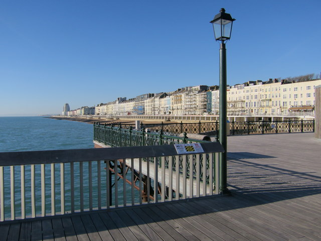
Opened 1872 - Closed 2007 - Length 910ft
The pier was closed in 2006 and 2007 due to structural decay, and was due to be restored after the council had completed a compulsory purchase order.
On 5th October 2010, the pier was set alight by arsonists destroying most of the buildings. This was just hours after a competition was opened to redesign the pier. Despite taking four days to put out, the pier itself was said to be structurally sound, and the competition was still run, with a firm chosen.
In November 2012 a £11.4million lottery grant was awarded towards the pier rebuild. The total cost is only estimated at £13.9 million as the accommodation will be signicantly smaller than its original form.
It reopened on March 2016 and went on to win the RIBA Stirling Prize in 2017.
Also see Pleasure Piers of Great Britain Link
Seaside pleasure piers were first built during the early 19th century, and became popular during the Victorian era of the mid to late 1800s. During this period, the railways were expanding allowing mass tourism to the coastal resort towns. Pleasure piers allowed holiday makers to promenade over and alongside the sea at all times. Since the introduction of commercial flights from the 1950s holiday makers flocked abroad and the seaside towns lost the tourist trade. Many piers became unprofitable and fell into disrepair. Many have since been destroyed by storms, demolished, or lay derelict. The earliest pier was built at Ryde and opened 1814. It is still open to this day.
See pleasure piers of Great Britain Link
 Map © Crown Copyright")
- Grid Square
- TQ8109, 2134 images (more nearby 🔍)
- Photographer
- Oast House Archive (more nearby)
- Date Taken
- Thursday, 1 December, 2016 (more nearby)
- Submitted
- Saturday, 3 December, 2016
- Subject Location
-
OSGB36:
 TQ 811 090 [100m precision]
WGS84: 50:51.1563N 0:34.3142E - Camera Location
-
OSGB36: TQ 811 090
- View Direction
- West-southwest (about 247 degrees)