2016
NS3975 : Boer War Memorial
taken 7 years ago, near to Dumbarton, West Dunbartonshire, Scotland
This is 1 of 3 images, with title Boer War Memorial in this square
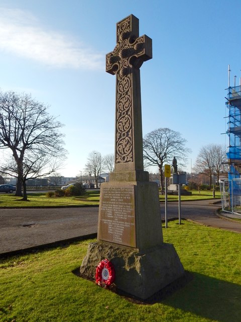
Boer War Memorial
It has a wreath this year, but, according to local newspaper reports, the memorial had largely gone unnoticed before then, because few people had taken the time to look at it and see what it was. For a similar picture of mine from 2012, see NS3975 : Boer War Memorial.
In the right background, in the present picture, is a corner of NS3975 : Dumbarton Municipal Buildings, undergoing refurbishment. A NS3975 : Statue of Peter Denny can be seen to the right of the memorial, behind some signs.
In the right background, in the present picture, is a corner of NS3975 : Dumbarton Municipal Buildings, undergoing refurbishment. A NS3975 : Statue of Peter Denny can be seen to the right of the memorial, behind some signs.
Boer War Memorial
The memorial, which was erected in 1904, stands near the south-eastern corner of Dumbarton Municipal Buildings Link
Dumbarton Municipal Buildings
The buildings were erected on College Park (the former grounds of College Park House). The land was bought from the railway company by Lord Overtoun, and gifted by him to the burgh. The buildings, by James Thomson, were officially opened in 1903. The College Bow Link now stands in the grounds, as do a Boer War Memorial Link and a statue of Peter Denny Link
 Map © Crown Copyright")
TIP: Click the map for more Large scale mapping
- Grid Square
- NS3975, 671 images (more nearby 🔍)
- Photographer
- Lairich Rig (more nearby)
- Date Taken
- Sunday, 4 December, 2016 (more nearby)
- Submitted
- Wednesday, 14 December, 2016
- Subject Location
-
OSGB36:
 NS 3978 7550 [10m precision]
WGS84: 55:56.7449N 4:34.0309W - Camera Location
-
OSGB36: NS 3978 7550
- View Direction
- West-southwest (about 247 degrees)