TG2004 : WW2 remains of a military hut
taken 7 years ago, near to Keswick, Norfolk, England
Keswick Hall > Link was one of the stately homes of the Gurney family. After the death of Margaret Jane, wife of John Henry Gurney, in 1940, the hall was immediately requisitioned by the army. Although there is no further information about the unit stationed there, P Turner, a resident of Cringleford in his recollection of an attack on Cringleford by a German fighter aircraft provides the following clue: "I think on reflection the pilot may have been aiming for the petrol pumps outside the garage used by the army from Keswick Hall, an RASC (Royal Army Service Corps) Unit". The garage referred to was Cringleford garage (near the church), owned by HE (Herbert Edward) Taylor & Co (who also owned the Eaton Coachworks). It had up to 12 petrol pumps at one time.
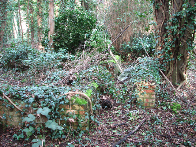
Whether the camp at Keswick Hall was a headquarters or used for training purposes is to date not known. It has however been recorded by Norfolk Heritage (NHER) as comprising a number of six or perhaps seven Nissen huts arranged in two groups, which the experts say they can see in aerial views dating from between 1942 and 1951. The remaining brick foundations, however, indicate that at least some of the buildings were not Nissen but so-called Asbestos huts which look similar but have a flatter curve and are distinguished by having brick foundation walls. The intact (albeit overgrown) foundations of two huts, each measuring 12 by 5 metres, are still in place. They are adjoined by sections of brick walls and heaps of rubble where other huts used to stand. A manhole and what appears to have been a cesspit can also still be found in the immediate vicinity.
S Horlock, the NHER's researcher and author of the report published in March 2009, furthermore mentions an area which is now covered by the car park adjacent to the tennis court > Link and a "metal-roofed structure" that he can see at this location which, so he thinks, has the same roof profile as the huts and from this he conjures an air raid shelter: "immediately adjacent to this possible Nissen segment is an elongated vegetation-covered area. Whilst it is entirely possible that this feature merely represents an overgrown area in amongst the outbuildings, it is feasible that this represents an earthen covered component to an air raid shelter" and "two small trenches located to the west of the hall, likely to represent the remains of small trench shelters dug for use as air raid shelter, although it is possible that they served another defensive or training function" at what is presently known as Ellis Garden, west of College Lane, long since built over > Link.
An aerial photograph dating from 1945 is said to depict numerous trucks parked in the hall grounds in September 1945, suggesting that the camp was still in use at that time.
 Map © Crown Copyright")
- Grid Square
- TG2004, 136 images (more nearby 🔍)
- Photographer
- Evelyn Simak (more nearby)
- Date Taken
- Thursday, 2 March, 2017 (more nearby)
- Submitted
- Sunday, 5 March, 2017
- Subject Location
-
OSGB36:
 TG 20 04 [1000m precision]
WGS84: 52:35.6123N 1:15.2444E