2017
TQ0187 : Gantry and A40 bridge over M25
taken 7 years ago, near to Gerrards Cross, Buckinghamshire, England
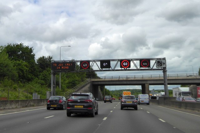
Gantry and A40 bridge over M25
Officially named the London Orbital and frequently derided as nothing more than a very big car park, the M25 is a 117-mile orbital motorway that encircles London; one of the world's biggest ring roads (Europe's second longest orbital road after the Berliner Ring, which is 122 miles). It is not, however, a continuous loop of motorway as the Dartford Crossing section (comprising the Dartford Tunnels and the Queen Elizabeth II Bridge) over the Thames and its approach roads are designated as the A282.
Constructed between 1975 and 1986, the M25 is reputedly the most expensive motorway Britain ever built, costing a total of £909m or roughly £7.5m per mile, but at the time of its planning, the demand for the road was considerably underestimated so that when it was finally completed in 1986, it was already out of date. Demand outstripped capacity within a few years and ever since then it's been very heavily congested.
The M25 is one of the UKs busiest motorways, carrying up to 200,000 vehicles and 10,000 HGVs per day (AADT - Annual Average Daily Traffic flow) on the section near to Heathrow Airport. Since its opening in the 1980s, the southern, western and eastern sections have been widened to largely dual four lane (D4M) standard, but much of the motorway retains its dual three lane road (D3M) cross-section as originally built.
The M25 was home to England's first Variable Speed Limits on motorways between the A3 and M4 in the early 1990s.
Link cbrd
cbrd
Link SABRE
See other images of M25, London Orbital Motorway
Constructed between 1975 and 1986, the M25 is reputedly the most expensive motorway Britain ever built, costing a total of £909m or roughly £7.5m per mile, but at the time of its planning, the demand for the road was considerably underestimated so that when it was finally completed in 1986, it was already out of date. Demand outstripped capacity within a few years and ever since then it's been very heavily congested.
The M25 is one of the UKs busiest motorways, carrying up to 200,000 vehicles and 10,000 HGVs per day (AADT - Annual Average Daily Traffic flow) on the section near to Heathrow Airport. Since its opening in the 1980s, the southern, western and eastern sections have been widened to largely dual four lane (D4M) standard, but much of the motorway retains its dual three lane road (D3M) cross-section as originally built.
The M25 was home to England's first Variable Speed Limits on motorways between the A3 and M4 in the early 1990s.
Link
Link
See other images of M25, London Orbital Motorway
 Map © Crown Copyright")
TIP: Click the map for more Large scale mapping
- Grid Square
- TQ0187, 48 images (more nearby 🔍)
- Photographer
- David Smith (more nearby)
- Date Taken
- Tuesday, 30 May, 2017 (more nearby)
- Submitted
- Saturday, 17 June, 2017
- Subject Location
-
OSGB36:
 TQ 0154 8721 [10m precision]
WGS84: 51:34.4773N 0:32.1698W - Camera Location
-
OSGB36: TQ 0155 8710
- View Direction
- NORTH (about 0 degrees)