2017
SY4690 : East Cliff
taken 7 years ago, near to West Bay, Dorset, England
This is 1 of 14 images, with title East Cliff in this square
East Cliff
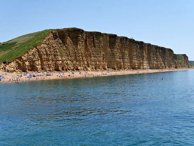
Viewed here from the harbour at West Pier, the East Cliff together with the beach below it is famous as the setting for the discovery of Danny Latimer's body in the first series of Broadchurch.
The cliffs to the east of the harbour, between West Bay and Burton Bradstock, are composed of material laid down in the Toarcian Age toward the end of the Early Jurassic period. The soft, fine-grained sandstone contains regular narrow bands that are calcite-cemented and more resistant to weathering, giving it a characteristic banded appearance alternating between harder and softer materials. The cliff's distinctive reddish colour is a result of oxidisation of fine pyrite grains.
The cliffs to the east of the harbour, between West Bay and Burton Bradstock, are composed of material laid down in the Toarcian Age toward the end of the Early Jurassic period. The soft, fine-grained sandstone contains regular narrow bands that are calcite-cemented and more resistant to weathering, giving it a characteristic banded appearance alternating between harder and softer materials. The cliff's distinctive reddish colour is a result of oxidisation of fine pyrite grains.
Broadchurch
Broadchurch was a British television crime drama starring David Tennant and Olivia Colman. The first series, which originally aired on ITV from 4 March 2013 to 22 April 2013 and received widespread critical acclaim and high viewership ratings, focused on the death of an 11-year-old boy and the impact of grief, mutual suspicion and media attention on the town. It was set in a fictional, close-knit small town in Dorset and most of the location shots were filmed at West Bay (Bridport Harbour).
 Map © Crown Copyright")
TIP: Click the map for more Large scale mapping
- Grid Square
- SY4690, 1030 images (more nearby 🔍)
- Photographer
- David Dixon (more nearby)
- Date Taken
- Sunday, 18 June, 2017 (more nearby)
- Submitted
- Friday, 23 June, 2017
- Subject Location
-
OSGB36:
 SY 466 900 [100m precision]
WGS84: 50:42.4791N 2:45.4149W - Camera Location
-
OSGB36: SY 461 901
- View Direction
- EAST (about 90 degrees)