ST8291 : Tombs in the churchyard, Leighterton
taken 7 years ago, near to Leighterton, Gloucestershire, England
The church consists of nave, chancel, and west tower of 13th century origin, 14th century south porch, and 19th century north aisle and vestry.
As with many churches it was quite dilapidated by the early 19th century. The first rebuild of that century involved extending the chancel beyond the original east wall in a 'hammer-head' layout, with pews or choirs stall at the side of the altar. The church was more substantially rebuilt in 1876-7 by Waller of Gloucester. This restored the east end to its original size, but resulted in new windows also being inserted in the south wall of the chancel. The requirement to cater for an expanded congregation required the addition of the north aisle.
The main original features remaining are the unusually flat 13th century chancel arch, and the stone section of the tower, including the arch into the nave. The window openings in the south wall of the nave are original but new windows have been inserted.
The upper, timber framed, part of the tower is also from the 19th century rebuilding.
Of interior fittings, the oldest is the piscina in the chancel, of the 13th century. The font is a fine example of the 14th century, with finely carved panels depicting the symbols of the passion. It is not original to the church but apparently was transferred from St Mary's church Wotton-under-edge in the 19th century.
The tower holds an interesting selection of bells. There are two traditional bells, one of 1510 and one of 1882, together with a set of 8 tubular bells, Harrington's Patent, installed in 1888.
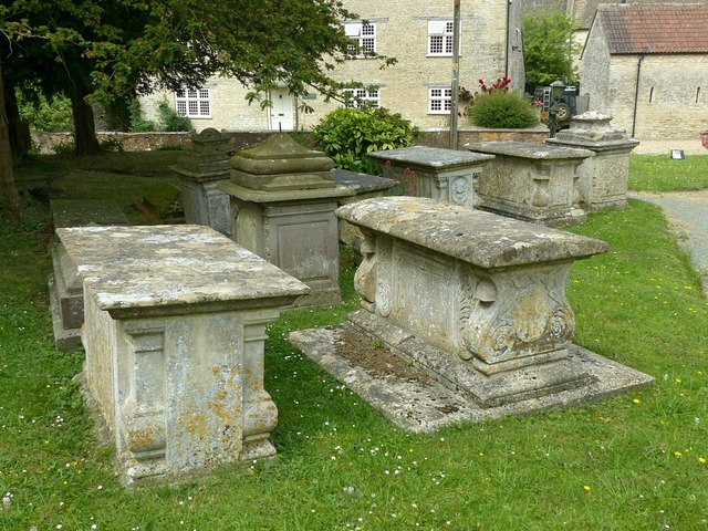
The churchyard must not be overlooked. There are a total of 11 chest and pedestal tombs, typical of the Cotswolds, which have listed status, one being Grade II*.
The church is Listed Grade II*.
Listed buildings and structures are officially designated as being of special architectural, historical or cultural significance. There are over half a million listed structures in the United Kingdom, covered by around 375,000 listings.
Listed status is more commonly associated with buildings or groups of buildings, however it can cover many other structures, including bridges, headstones, steps, ponds, monuments, walls, phone boxes, wrecks, parks, and heritage sites, and in more recent times a road crossing (Abbey Road) and graffiti art (Banksy 'Spy-booth') have been included.
In England and Wales there are three main listing designations;
Grade I (2.5%) - exceptional interest, sometimes considered to be internationally important.
Grade II* (5.5%) - particularly important buildings of more than special interest.
Grade II (92%) - nationally important and of special interest.
There are also locally listed structures (at the discretion of local authorities) using A, B and C designations.
In Scotland three classifications are also used but the criteria are different. There are around 47,500 Listed buildings.
Category A (8%)- generally equivalent to Grade I and II* in England and Wales
Category B (51%)- this appears generally to cover the ground of Grade II, recognising national importance.
Category C (41%)- buildings of local importance, probably with some overlap with English Grade II.
In Northern Ireland the criteria are similar to Scotland, but the classifications are:
Grade A (2.3%)
Grade B+ (4.7%)
Grade B (93%)
Read more at Wikipedia Link
 Map © Crown Copyright")
- Grid Square
- ST8291, 85 images (more nearby 🔍)
- Photographer
- Alan Murray-Rust (more nearby)
- Date Taken
- Tuesday, 27 June, 2017 (more nearby)
- Submitted
- Monday, 3 July, 2017
- Subject Location
-
OSGB36:
 ST 8236 9106 [10m precision]
WGS84: 51:37.0851N 2:15.3708W - Camera Location
-
OSGB36: ST 8237 9105
- View Direction
- West-northwest (about 292 degrees)