NY8053 : Allen Smelt Mill Chimney
taken 7 years ago, 3 km from Ninebanks, Northumberland, England
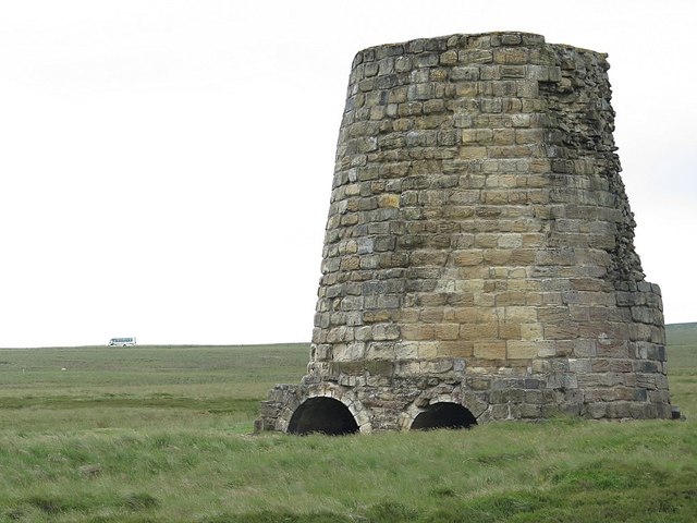
There are two chimneys on Flow Moss. The most southerly chimney (shown here), into which both flues pass, has undergone consolidation and is visible as a well preserved structure 7m in diameter. It is built of regular sandstone blocks and was formerly higher than its present 6m. There are two arched flue openings at its square base with the remains of mortice holes. A fragment of a central dividing wall is visible within the chimney NY8053 : Inside Allen Smelt Mill Chimney. The most northerly chimney NY8053 : Snow drift in collapsed flue, approximately 40m north of the first, stands 25m high and 4m in diameter, and contains a single arched flue opening; the earliest flue bypasses this chimney in favour of the second, although traces of an earlier course to it are visible as a slight earthwork.
Allen Lead Smelt Mill was first recorded as early as 1692 when it was owned by the Bacon family. From 1786 the mill was owned by the Beaumont Company which added long flues up to the fell-top in 1808 and between 1845 and 1850. As noxious furnace fumes travelled up the flues, they cooled and condensed on the walls. These deposits were then chipped away for their lead and silver content via doorways in the flue walls. Large parts of the flues survive as ribbon-like mounds up to 7m wide and 2m high, running across fields for 3.5km until they end at the two chimneys. This flue system is one of the best preserved in England. The chimneys ceased operating in 1896 and are a Scheduled Monument protected by law.
Allen Smelt Mill, flue system and chimneys: Link
 Map © Crown Copyright")
- Grid Square
- NY8053, 192 images (more nearby 🔍)
- Photographer
- Andrew Curtis (more nearby)
- Date Taken
- Friday, 23 June, 2017 (more nearby)
- Submitted
- Wednesday, 5 July, 2017
- Subject Location
-
OSGB36:
 NY 8075 5368 [10m precision]
WGS84: 54:52.6504N 2:18.0921W - Camera Location
-
OSGB36: NY 80741 53736
- View Direction
- South-southeast (about 157 degrees)