2017
SP5107 : Blue plaque to Honor Fell, outside Wychwood School, Banbury Road, Oxford
taken 7 years ago, near to Marston, Oxfordshire, England
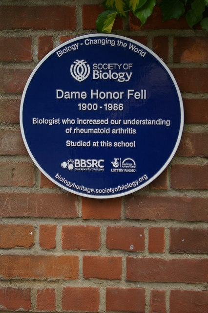
Blue plaque to Honor Fell, outside Wychwood School, Banbury Road, Oxford
Dame Honor Fell (1900-1986), biologist and zoologist, did important work on rheumatoid arthritis. Her papers are held at the Wellcome Library and have been digitised: see Link . For more information about her, see Link.
Wychwood School, founded in 1897, is an independent day and boarding school for girls aged from 11 to 18: details at Link. At the time of its foundation the school was considered somewhat advanced because of its emphasis on educating girls in science: as the plaque indicates, this approach clearly paid off.
Wychwood School, founded in 1897, is an independent day and boarding school for girls aged from 11 to 18: details at Link
Blue Plaques
A blue plaque is a permanent sign installed in a public place to commemorate a link between that location and a famous person or event, serving as a historical marker.
The world's first blue plaques were erected in London, England in the nineteenth century to mark the homes and workplaces of famous people.
The original blue plaque scheme started in the 1860s, is now run by English Heritage in London. It is believed to be the oldest such scheme in the world.
There are currently about 850 plaques in London.
 Map © Crown Copyright")
TIP: Click the map for more Large scale mapping
- Grid Square
- SP5107, 360 images (more nearby 🔍)
- Photographer
- Christopher Hilton (more nearby)
- Date Taken
- Thursday, 4 May, 2017 (more nearby)
- Submitted
- Sunday, 23 July, 2017
- Subject Location
-
OSGB36:
 SP 5108 0780 [10m precision]
WGS84: 51:45.9934N 1:15.6723W - Camera Location
-
OSGB36: SP 5107 0780
- View Direction
- EAST (about 90 degrees)