2017
TG3104 : Seeding broad-leaved dock
taken 7 years ago, near to Rockland st Mary, Norfolk, England
Seeding broad-leaved dock
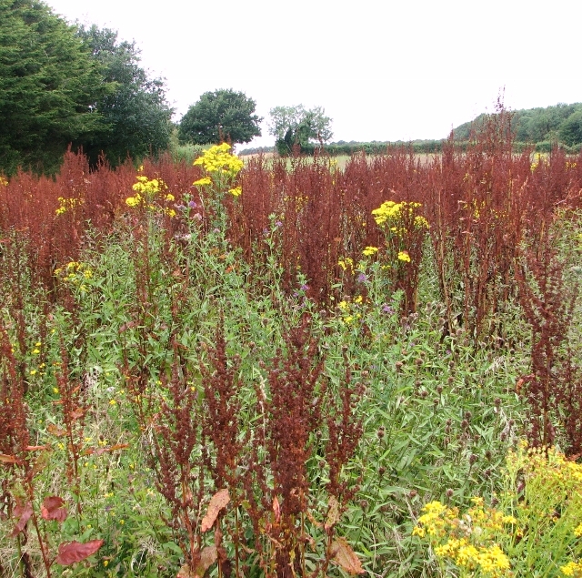
Broad-leaved dock (Rumex obtusifolius) is one of the five injurious weeds named in the 1959 Weeds Act and is very frequently seen in pasture land. Its toxic component is calcium oxalate, which can irritate the skin, mouth, tongue, and throat, resulting in throat swelling, breathing difficulties, burning pain, and stomach upset. As oxalates in plants preferentially bind to calcium in the body, regular ingestion in small amounts can lead to calcium deficiency and to the build up of kidney stones if the calcium oxalate formed is not excreted. Due to its unpleasant taste it is, however, not a plant that is regularly consumed. Another name for Broad-leaved dock used to be butter dock because its large leaves were used to wrap and conserve butter.
Ragwort (Jacobaea vulgaris) the yellow-flowering plant seen here, contains pyrrolizidine alkaloids, which are hepatotoxic and can cause complete liver failure. There is, however, no evidence that ragwort causes harm by contact or inhalation, and in fact very little evidence of harm to humans except for those with pre-existing liver damage. Ragwort may be more of a problem for livestock and especially horses, as it retains its toxicity even when dried and can lead to fatal poisoning in horses if contained in the hay they are being fed. Other compounds in ragwort that can produce contact dermatitis. For this reason, the wearing of gloves is advised when removing the plant.
Ragwort (Jacobaea vulgaris) the yellow-flowering plant seen here, contains pyrrolizidine alkaloids, which are hepatotoxic and can cause complete liver failure. There is, however, no evidence that ragwort causes harm by contact or inhalation, and in fact very little evidence of harm to humans except for those with pre-existing liver damage. Ragwort may be more of a problem for livestock and especially horses, as it retains its toxicity even when dried and can lead to fatal poisoning in horses if contained in the hay they are being fed. Other compounds in ragwort that can produce contact dermatitis. For this reason, the wearing of gloves is advised when removing the plant.
 Map © Crown Copyright")
TIP: Click the map for more Large scale mapping
- Grid Square
- TG3104, 114 images (more nearby 🔍)
- Photographer
- Evelyn Simak (more nearby)
- Date Taken
- Saturday, 29 July, 2017 (more nearby)
- Submitted
- Saturday, 29 July, 2017
- Subject Location
-
OSGB36:
 TG 3185 0479 [10m precision]
WGS84: 52:35.4854N 1:25.2920E - Camera Location
-
OSGB36: TG 3197 0481
- View Direction
- WEST (about 270 degrees)