SH5571 : Beach Road, Menai Bridge
taken 7 years ago, near to Menai Bridge, Isle of Anglesey/Sir Ynys Mon, Wales
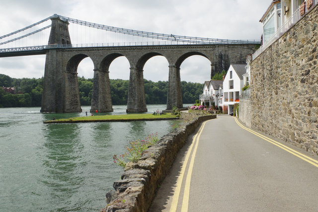
Designed by Thomas Telford and completed in 1826, it was the only road link between Anglesey and the mainland (and an essential component of the London - Holyhead route, with its onward links to Ireland) until the completion of the road deck on the nearby Pont Britannia in 1980. One requirement was that it should have sufficient clearance above the water to allow high masted Royal Navy ships to pass through at high tide.
The towers were built of limestone from which were suspended 16 wrought iron chains cables. Over the years it has undergone various changes to be able to handle greater loads, including the replacement of the chain cables with steel ones in 1938-40.
Although long distance traffic now uses the Pont Britannia, the bridge still serves an important role in linking Menai Bridge with Bangor.
Grade I listed - see Link.
 Map © Crown Copyright")
- Grid Square
- SH5571, 727 images (more nearby 🔍)
- Photographer
- Stephen McKay (more nearby)
- Date Taken
- Tuesday, 25 July, 2017 (more nearby)
- Submitted
- Tuesday, 1 August, 2017
- Subject Location
-
OSGB36:
 SH 5561 7153 [10m precision]
WGS84: 53:13.2685N 4:9.8481W - Camera Location
-
OSGB36: SH 5570 7161
- View Direction
- Southwest (about 225 degrees)