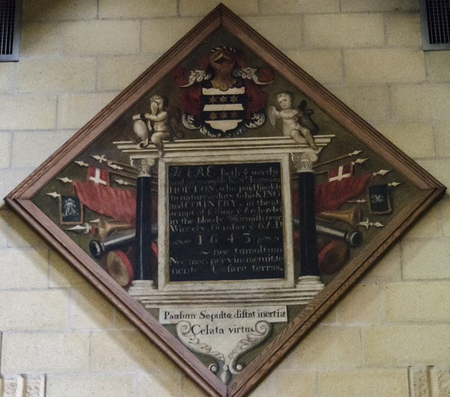
TF2569 : Memorial to Sir Ingram Hopton, Horncastle church
taken 7 years ago, near to Horncastle, Lincolnshire, England
Grade II listed
The church dates from the early 13th century onwards, and was restored in 1859-61 by Ewan Christian.
It is built in green sandstone and has a west tower with spirelet, nave with north and south aisles, chancel with north and south aisles, north porch and vestry.
The tower dates from circa 1200, and was remodelled in 1861. The upper part is from the decorated period.
The nave arcades are of five bays and date from the early 13th century. These were restored in 1861.
The chancel has 15th century arcades, two to the north and three south, again heavily restored. The chancel arch dates from the Victorian restoration. The reredos also dates from this time, and is by C. E. Giles.
There is a Memorial brass to Sir Lionel Dymoke, died 1519, he was knighted at Siege of Tournai, and was Sheriff of Lincolnshire 1516.
On the wall of the south aisle are mounted 13 scythes, which were thought to have been used in the Lincolnshire rising of 1536, although this is unlikely , despite Horncastle being one of the centres of the rebellion.
There are several stained-glass windows, with some by Heaton Butler and Bayne, and one by Preedy.
The church pipe organ was recently replaced with a new digital version. The freed up space has been converted into a Coffee area.
 Map © Crown Copyright")
- Grid Square
- TF2569, 485 images (more nearby 🔍)
- Photographer
- Julian P Guffogg (more nearby)
- Date Taken
- Monday, 21 August, 2017 (more nearby)
- Submitted
- Wednesday, 23 August, 2017
- Subject Location
-
OSGB36:
 TF 2585 6955 [10m precision]
WGS84: 53:12.4876N 0:7.0245W