2017
M4429 : Moor Park cemetery, Moor, Knocknacreeva, Athenry, east Galway
taken 7 years ago, 6 km W of Athenry, Co Galway, Ireland
Moor Park cemetery, Moor, Knocknacreeva, Athenry, east Galway
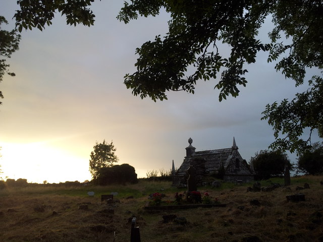
This cemetery is located within a stone-walled enclosure. Centrally located within the enclosure are fragments of a religious building (possibly Cistercian). A north wall and a small stump of west wall remain standing.
Scattered stones throughout the site are probably the remnants of the remaining walls. A 19th-century mausoleum is located at what would have been the centre of the original building. The mausoleum belonged to the Lambert family of Castle Lambert and Moor, the local "Big Houses" lying a short distance (~2km) north east and east of here, respectively. Unfortunately, the mausoleum was desecrated (at least as far back as 1975) and the chamber is now empty. Children's graves are common here, and modern headstones and memorial plaques have been erected to local children who had died in the 1930s, 40s. Two well-defined adult graves are also present. One is that of a local man, Tom Egan, who died in 1920 at the hands of the notorious Black & Tans. Egan's pub, where the shooting took place, is still extant and trading and is situated ~ 1.5km NW of here on the main Galway-Monivea road. Directly outside the entrance gate at the south wall is a large deeply sunk well that is enclosed by a stone wall. An interesting local history book about this region is "The Lamberts of Athenry" by Finbarr O'Regan. The book discusses the various Lambert families here and in other parts of County Galway, the connection with Edward Carson - the "architect of Northern Ireland," and the lives and stories of various locals.
Scattered stones throughout the site are probably the remnants of the remaining walls. A 19th-century mausoleum is located at what would have been the centre of the original building. The mausoleum belonged to the Lambert family of Castle Lambert and Moor, the local "Big Houses" lying a short distance (~2km) north east and east of here, respectively. Unfortunately, the mausoleum was desecrated (at least as far back as 1975) and the chamber is now empty. Children's graves are common here, and modern headstones and memorial plaques have been erected to local children who had died in the 1930s, 40s. Two well-defined adult graves are also present. One is that of a local man, Tom Egan, who died in 1920 at the hands of the notorious Black & Tans. Egan's pub, where the shooting took place, is still extant and trading and is situated ~ 1.5km NW of here on the main Galway-Monivea road. Directly outside the entrance gate at the south wall is a large deeply sunk well that is enclosed by a stone wall. An interesting local history book about this region is "The Lamberts of Athenry" by Finbarr O'Regan. The book discusses the various Lambert families here and in other parts of County Galway, the connection with Edward Carson - the "architect of Northern Ireland," and the lives and stories of various locals.
Loading map... (JavaScript required)
- Grid Square
- M4429, 4 images (more nearby 🔍)
- Photographer
- DeeEmm (more nearby)
- Date Taken
- Wednesday, 23 August, 2017 (more nearby)
- Submitted
- Thursday, 24 August, 2017
- Subject Location
-
Irish:
 M 440 290 [100m precision]
WGS84: 53:18.5573N 8:50.4416W - Camera Location
-
Irish: M 440 290
- View Direction
- Northwest (about 315 degrees)