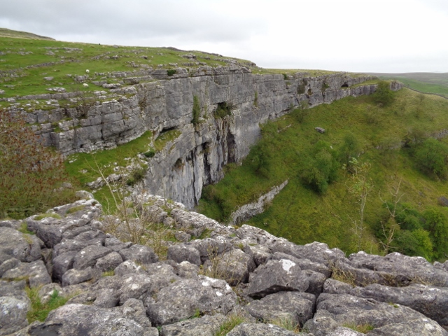
SD8964 : Limestone beds at Malham Cove
taken 7 years ago, near to Malham, North Yorkshire, England
Limestone pavement is a natural karst landform consisting of a flat, incised surface of exposed limestone that resembles an artificial pavement. The term is mainly used in the UK where many of these landforms have developed distinctive surface patterning resembling paving blocks.
Conditions for limestone pavements are created when an advancing glacier scrapes away overburden and exposes horizontally-bedded limestone, with subsequent glacial retreat leaving behind a flat, bare surface. Limestone is slightly soluble in water and especially in acid rain, so corrosive drainage along joints and cracks in the limestone can produce slabs called "clints" isolated by deep fissures called "grikes" or "grykes". If the grykes are fairly straight and the clints are uniform in size, the resemblance to man-made paving stones is striking, but often they are less regular.
Malham Cove is a natural limestone formation 1 km north of the village of Malham. A well-known beauty spot, it is a large, curved limestone cliff at the head of a valley, with a fine area of limestone pavement at the top.
Originally, a large waterfall flowed over the cove as a glacier melted above it. The remnant of a stream which once fell over the cliff now flows out of the lake of Malham Tarn, on the moors 2 km north of the cove. That stream now disappears underground at the aptly named 'Water Sinks', 1.5 kilometres before its valley reaches the top of the cove. A stream of a similar size (Malham Beck) emerges from a cave at the bottom of the cove. It used to be assumed that the two streams were one and the same. However, experiments with dyes have now shown that two separate streams go underground at different locations, cross paths without mixing behind the cliff, and re-emerge a couple of kilometres apart.
The lip of the cove has been more heavily eroded than the sides, creating a curved shape. A colossal amount of water used to flow over this waterfall, which measures 80 m high and over 300 m wide. Nowadays the underlying cave systems have a large enough capacity to swallow any flood waters before it reaches the fall.
The valley was formed at the end of the last ice age when the ground was frozen. The frozen ground meant that meltwater from the melting ice sheet formed a large river flowing over the surface, eroding the valley that we see today. The water from this river flowed over Malham Cove to form a huge waterfall. When the climate warmed around 12,000 years ago the ground thawed and the river in the valley disappeared underground leaving the valley dry as we see it today.
 Map © Crown Copyright")
- Grid Square
- SD8964, 525 images (more nearby 🔍)
- Photographer
- Ashley Dace (more nearby)
- Date Taken
- Monday, 9 October, 2017 (more nearby)
- Submitted
- Wednesday, 25 October, 2017
- Subject Location
-
OSGB36:
 SD 8976 6412 [10m precision]
WGS84: 54:4.3744N 2:9.4788W - Camera Location
-
OSGB36: SD 8972 6413
- View Direction
- EAST (about 90 degrees)