2017
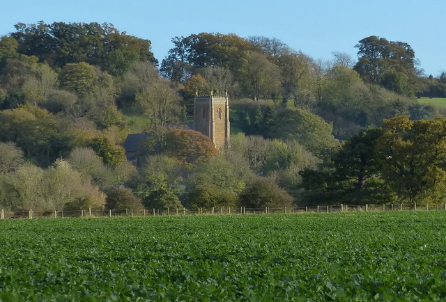
SK8333 : St James's church at Woolsthorpe-by-Belvoir
taken 6 years ago, near to Woolsthorpe by Belvoir, Lincolnshire, England
St James's church at Woolsthorpe-by-Belvoir
Grade II listed
The former church of St James, Woolsthorpe, was burnt down by Roundheads during the Civil War.
The present church is on the site of a former Chapel of Ease, and was built by G. G. Place of Nottingham and finished in 1847 at a cost of £3500. It was originally intended to have a spire.
There is a western tower, nave with aisles and clerestory, chancel, south porch, and vestry. It is built of ironstone with ashlar dressings and slate roofs.
The tower is of three stages, and was unfinished until 1893. It has a battlemented parapet and crocketted pinnacles.
The nave has four bay arcades with octagonal piers. The clerestory has small quatrefoil windows.
The chancel has a five light east window and two windows to the south, with a priests door. The north side has a tomb recess, and the walls are painted with floral designs by Lady Adeliza Manners, some of which has been lost. The floor has Minton tiles.
There is a richly carved octagonal font, and a small organ by Kirkland. The doors have painted text over them.
The church suffered from a serious water leak in the 1990s, and the church was closed in 2008 for safety reasons. The church has since reopened, and the pews have been removed so that the scale of further work needed can be assessed. There are future plans to integrate the church into the community with the addition of a cafe, public services, and outdoor pursuits centre etc.
See other images of St James's church, Woolsthorpe by Belvoir
 Map © Crown Copyright")
TIP: Click the map for more Large scale mapping
- Grid Square
- SK8333, 61 images (more nearby 🔍)
- Photographer
- Mat Fascione (more nearby)
- Date Taken
- Sunday, 29 October, 2017 (more nearby)
- Submitted
- Wednesday, 1 November, 2017
- Subject Location
-
OSGB36:
 SK 836 338 [100m precision]
WGS84: 52:53.7199N 0:45.4982W - Camera Location
-
OSGB36: SK 829 343
- View Direction
- Southeast (about 135 degrees)