2017
SU9109 : Halnaker Hill WWII RDF station - overview
taken 6 years ago, near to Halnaker, West Sussex, England
Halnaker Hill WWII RDF station - overview
-
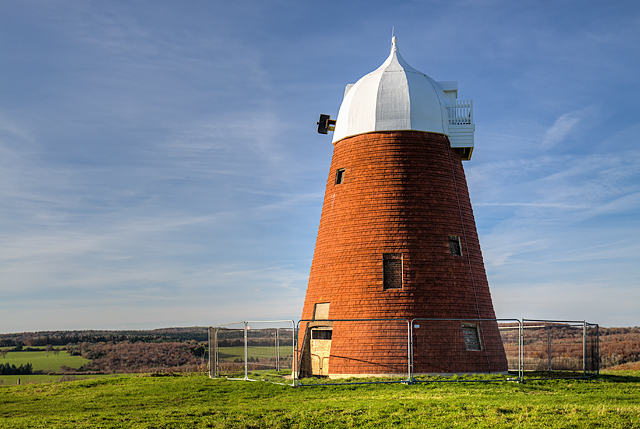
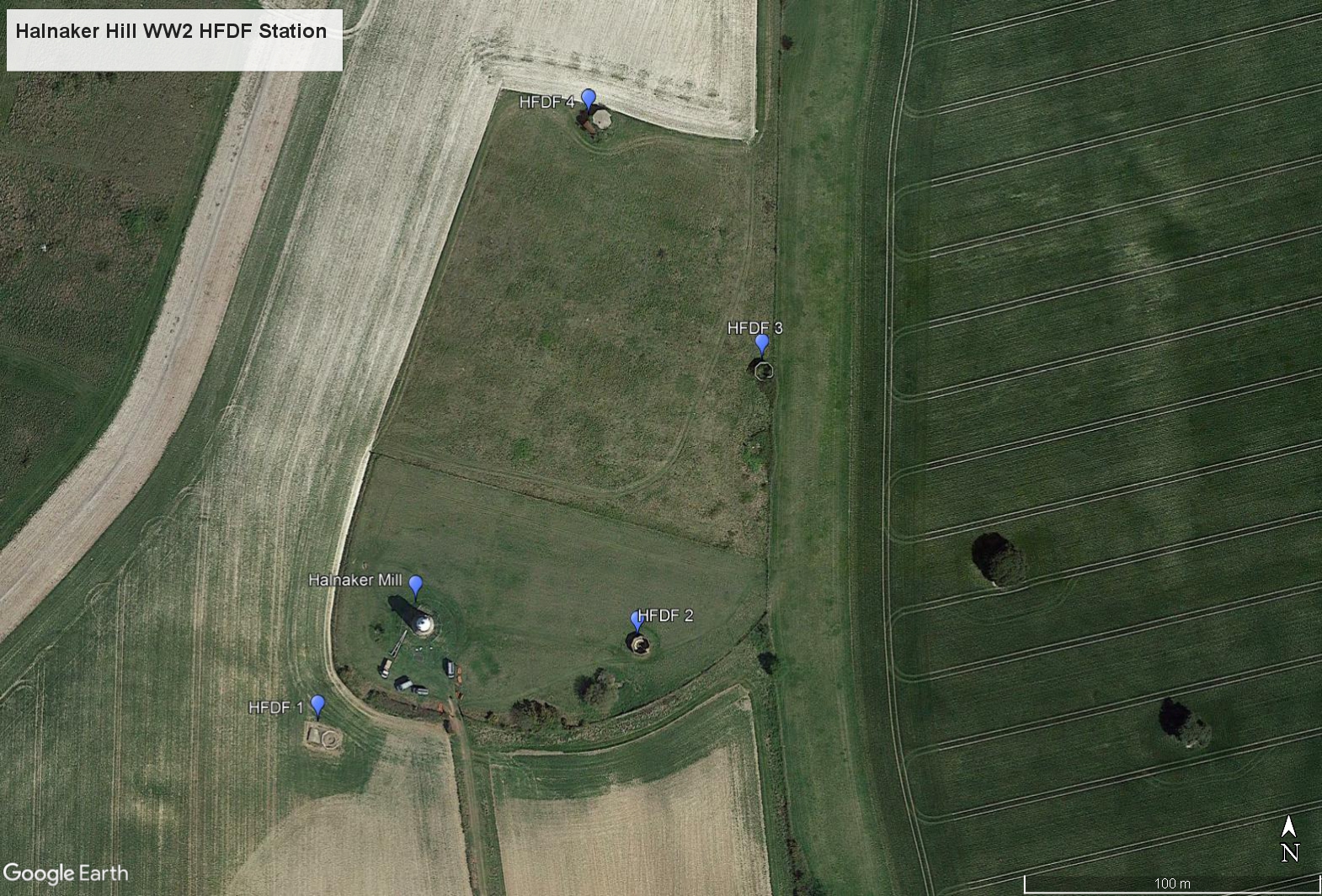
Surrounding the iconic Halnaker Windmill (restored for the third time and awaiting sails) are the remains of four separate WW2 radio direction finding stations about 100 metres apart in a semicircular arc on the east side of Halnaker Hill. Not to be confused with RDF the acronym given to the British Chain Home radar system in operation during WW2, the site and others like it, were nevertheless closely associated with it. Due to the coastal locations of the Chain Home system, radar coverage inland was mostly non-existent, and therefore purpose built direction finding stations were built inland in order to track, identify and direct our own fighter aircraft. These stations (known as HFDF or "Huff-Duff") were able by a system of triangulation involving two or more stations to very accurately determine an aircraft's position and bearing from its radio transmissions. For more detail of the system see Link and for a description of the construction of a typical HFDF station see Link
Although by no means unique, the HFDF station on Halnaker Hill would appear to have differed from most set-ups in that it was a close proximity multi-station system. Single stations in groups of two or three 30 miles apart were the norm, linked by telephone to sector control centres. The purpose of multiple HFDF stations built close together is thought to have been to triangulate radio signals from aircraft relatively close to them. Unlike conventional stations, they did not need a long distance baseline in order to achieve that, and their siting close to airfields was probably no coincidence either (RAF Tangmere was nearby). Another theory is that the multi-station HFDF sites enabled the control of more than one squadron of aircraft at the same time. It is also thought that the individual HFDF site situated at Halnaker Hill to the south of the windmill (itself used by the Home Guard as an observation post during WW2) was built to provide coverage from the south-west, as the windmill would have interfered with VHF line of sight transmissions from that direction. Although by no means common, there are known to have been similar multiple station sites like the one at Halnaker Hill elsewhere in the country (e.g. Minster, Kent - near to the fighter airfield at Manston).
I am aware that Historic England have described the WW2 remains here as searchlight emplacements Link . I would respectfully suggest they are wrong in that assumption. Looking at photographs of typical searchlight batteries from WW2, it would seem impossible for a searchlight crew to operate such a device from within the confines of an octagonal blast wall. They needed a heck of a lot of room in which to operate, and are invariably seen out in the open with the searchlights and their associated equipment (CASL emplacements excepted). Yet another view is that these structures were gun emplacements. This can also be discounted for the aforementioned reason, and also because there is no record of an anti-aircraft battery having been sited here. The clue therefore is in the octagonal blast walls surrounding the octagonal concrete foundations for the wooden HFDF towers within. They are typical of the surviving remains of other HFDF stations throughout the country.
Google Earth view of the site: Link
Although the above information can be attributed to me, I am nonetheless grateful to Steve Thompson of the Pillbox Study Group for his opinion on the Halnaker Hill stations, and for clarifying the purpose of this type of multi-station HFDF.
**********
SU9109 : Halnaker Hill WWII RDF station - HFDF #1
Surrounding the iconic Halnaker Windmill (restored for the third time and awaiting sails) are the remains of four separate WW2 radio direction finding stations about 100 metres apart in a semicircular arc on the east side of Halnaker Hill. Not to be confused with RDF the acronym given to the British Chain Home radar system in operation during WW2, the site and others like it, were nevertheless closely associated with it. Due to the coastal locations of the Chain Home system, radar coverage inland was mostly non-existent, and therefore purpose built direction finding stations were built inland in order to track, identify and direct our own fighter aircraft. These stations (known as HFDF or "Huff-Duff") were able by a system of triangulation involving two or more stations to very accurately determine an aircraft's position and bearing from its radio transmissions. For more detail of the system see Link
Although by no means unique, the HFDF station on Halnaker Hill would appear to have differed from most set-ups in that it was a close proximity multi-station system. Single stations in groups of two or three 30 miles apart were the norm, linked by telephone to sector control centres. The purpose of multiple HFDF stations built close together is thought to have been to triangulate radio signals from aircraft relatively close to them. Unlike conventional stations, they did not need a long distance baseline in order to achieve that, and their siting close to airfields was probably no coincidence either (RAF Tangmere was nearby). Another theory is that the multi-station HFDF sites enabled the control of more than one squadron of aircraft at the same time. It is also thought that the individual HFDF site situated at Halnaker Hill to the south of the windmill (itself used by the Home Guard as an observation post during WW2) was built to provide coverage from the south-west, as the windmill would have interfered with VHF line of sight transmissions from that direction. Although by no means common, there are known to have been similar multiple station sites like the one at Halnaker Hill elsewhere in the country (e.g. Minster, Kent - near to the fighter airfield at Manston).
I am aware that Historic England have described the WW2 remains here as searchlight emplacements Link
Google Earth view of the site: Link
Although the above information can be attributed to me, I am nonetheless grateful to Steve Thompson of the Pillbox Study Group for his opinion on the Halnaker Hill stations, and for clarifying the purpose of this type of multi-station HFDF.
**********
SU9109 : Halnaker Hill WWII RDF station - HFDF #1
 Map © Crown Copyright")
TIP: Click the map for more Large scale mapping
- Grid Square
- SU9109, 23 images (more nearby 🔍)
- Photographer
- Mike Searle (more nearby)
- Date Taken
- Friday, 17 November, 2017 (more nearby)
- Submitted
- Saturday, 18 November, 2017
- Subject Location
-
OSGB36:
 SU 9199 0964 [10m precision]
WGS84: 50:52.7366N 0:41.6291W - Camera Location
-
OSGB36: SU 9203 0962
- View Direction
- West-northwest (about 292 degrees)