SE5158 : Beningbrough Hall, rear
taken 8 years ago, near to Nun Monkton, North Yorkshire, England
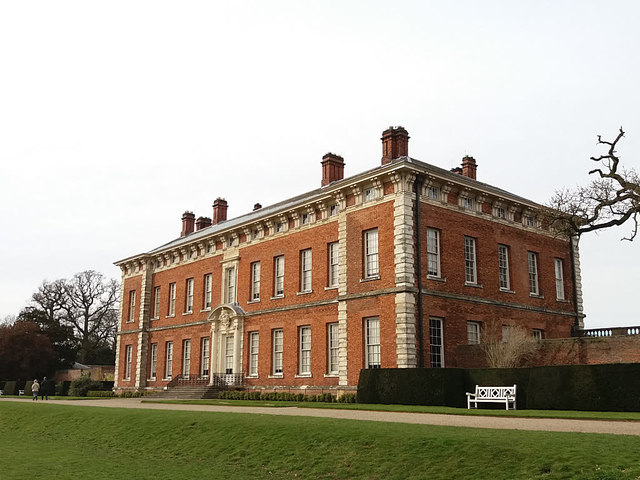
Beningbrough Hall is a large Georgian mansion situated approximately 6 miles (10 km) north west of York, near the village of Beningbrough. It was built in 1716 by a York landowner, John Bourchier III to replace his family's modest Elizabethan manor. Bourchier was High Sheriff of Yorkshire between 1719 and 1721.
During the Second World War the hall was occupied by the Royal Air Force then latterly, the Royal Canadian Air Force, when under No 6 Group of Bomber Command, they took over some of the bases in the region (such as the nearby RAF Linton-on-Ouse and RAF Leeming). It was acquired by the National Trust after it had been accepted by the government in lieu of death duties following the death of its last private owner, Lady Chesterfield, in 1957.
Externally, the house is a red-brick Georgian mansion with a grand drive running to the main frontage and a walled garden. The Hall is set in extensive grounds and is separated from them by an example of a ha-ha (a sunken wall) to prevent sheep and cattle entering the Hall's gardens or the Hall itself. The hall is a Grade I listed building (List entry Number: 1150998 LinkHistoric England).
Link
 Map © Crown Copyright")
- Grid Square
- SE5158, 243 images (more nearby 🔍)
- Photographer
- Stephen Craven (more nearby)
- Date Taken
- Sunday, 10 April, 2016 (more nearby)
- Submitted
- Wednesday, 27 December, 2017
- Subject Location
-
OSGB36:
 SE 5162 5855 [10m precision]
WGS84: 54:1.2228N 1:12.8175W - Camera Location
-
OSGB36: SE 5167 5849
- View Direction
- Northwest (about 315 degrees)