NZ0615 : The bridge over Thorsgill Beck
taken 7 years ago, near to Barnard Castle, County Durham, England
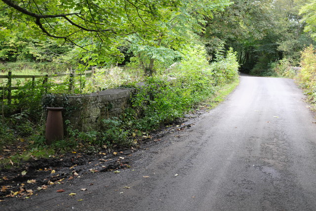
The Thorsgill Beck, where it joins the river Tees, is crossed by two bridges. The first, a narrow packhorse bridge of round profile dates from the 17th century, and the adjacent modern one from the late 18th or early 19th Century.
The Beck marks the parish boundary, and parish boundary stones for Egglestone Abbey and Startforth are placed at the two ends of the more recent bridge.
Both are grade II listed buildings, see Linkand Link
Listed buildings and structures are officially designated as being of special architectural, historical or cultural significance. There are over half a million listed structures in the United Kingdom, covered by around 375,000 listings.
Listed status is more commonly associated with buildings or groups of buildings, however it can cover many other structures, including bridges, headstones, steps, ponds, monuments, walls, phone boxes, wrecks, parks, and heritage sites, and in more recent times a road crossing (Abbey Road) and graffiti art (Banksy 'Spy-booth') have been included.
In England and Wales there are three main listing designations;
Grade I (2.5%) - exceptional interest, sometimes considered to be internationally important.
Grade II* (5.5%) - particularly important buildings of more than special interest.
Grade II (92%) - nationally important and of special interest.
There are also locally listed structures (at the discretion of local authorities) using A, B and C designations.
In Scotland three classifications are also used but the criteria are different. There are around 47,500 Listed buildings.
Category A (8%)- generally equivalent to Grade I and II* in England and Wales
Category B (51%)- this appears generally to cover the ground of Grade II, recognising national importance.
Category C (41%)- buildings of local importance, probably with some overlap with English Grade II.
In Northern Ireland the criteria are similar to Scotland, but the classifications are:
Grade A (2.3%)
Grade B+ (4.7%)
Grade B (93%)
Read more at Wikipedia Link
 Map © Crown Copyright")
- Grid Square
- NZ0615, 174 images (more nearby 🔍)
- Photographer
- Bob Harvey (more nearby)
- Date Taken
- Thursday, 21 September, 2017 (more nearby)
- Submitted
- Sunday, 14 January, 2018
- Subject Location
-
OSGB36:
 NZ 0624 1520 [10m precision]
WGS84: 54:31.9224N 1:54.3052W - Camera Location
-
OSGB36: NZ 0626 1518
- View Direction
- Northwest (about 315 degrees)