NS4074 : Disused railway bridge over Gruggies Burn
taken 6 years ago, near to Dumbarton, West Dunbartonshire, Scotland
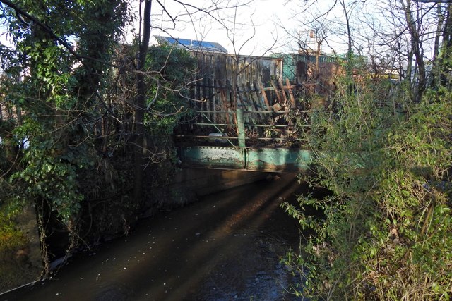
The bridge is marked on the 1:25000 map, and is located beside a path to the shore, but is easy to miss on account of intervening vegetation.
The track which it carried left the main Lanarkshire & Dumbarton Railway line (which is still in use) at NS40727461, at what is now the entrance of a sewage works. It then headed WSW, its former course still marked (as of 2018) by a line of trees passing through NS40557474, just north of and parallel to the northern edge of some works.
The track crossed Castle Road at NS40277478; its rails were still visible in the road in 2013, but they were later removed when the Allied Distillers site was redeveloped for housing.
At the start of the First World War, branches led throughout the area that would later be occupied by the Blackburn Aircraft Factory and then by Allied Distillers, between Gruggies Burn and Castle Road, while others led to the Leven Shipyard on the other side (the west) of Castle Road. At the start of the Second World War, the branches to the Leven Shipyard were still present, while those on the east of Castle Road were gone.
This burn in Dumbarton arises from the confluence of the Garshake and Overtoun Burns. In the past, some have linked its name to Bishop William Scroggie, but it is far more likely that it takes its name from the Grugie family who, in the 17th century, lived near the point where the turnpike road (on the line of what is now Dumbarton Road) crossed the burn by means of a bridge that was shown as "Grugiesbrigg" on Roy's Military Survey; the family name is now associated with the burn as a whole. The burn flows into the Clyde a little to the east of Dumbarton Rock. The prominent deep channel there on the shore was dredged by Blackburn Aircraft, who had a factory nearby, and who transported their completed machines across the Clyde by barge.
 Map © Crown Copyright")
- Grid Square
- NS4074, 243 images (more nearby 🔍)
- Photographer
- Lairich Rig (more nearby)
- Date Taken
- Friday, 19 January, 2018 (more nearby)
- Submitted
- Wednesday, 31 January, 2018
- Subject Location
-
OSGB36:
 NS 4041 7477 [10m precision]
WGS84: 55:56.3644N 4:33.4003W - Camera Location
-
OSGB36: NS 4041 7476
- View Direction
- NORTH (about 0 degrees)