2018
SK1271 : Dusting of snow near Taddington
taken 6 years ago, near to Blackwell, Derbyshire, England
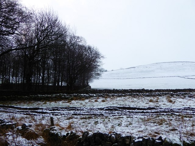
Dusting of snow near Taddington
Looking in the direction of South Top with the edge of a small copse or spinney on the left. At this altitude the snow was just a dusting, but as can be seen from the hill in the background, higher altitudes had a deeper covering.
Taken from the side of the A6 between Bakewell and Buxton near to the village of Taddington.
See also SK1271 : Senners Lane cuts across the landscape taken from approximately the same location.
Taken from the side of the A6 between Bakewell and Buxton near to the village of Taddington.
See also SK1271 : Senners Lane cuts across the landscape taken from approximately the same location.
The A6
The A6 is Britain's fourth longest road and one of the main historic north-south roads in England. It currently runs for 299 miles from Luton in Bedfordshire to Carlisle in Cumbria, although it formerly started at a junction with the A1 at Barnet.
Running north west from Luton, the road travels through Bedford, bypasses Rushden, Kettering and Market Harborough, continues through Leicester, Loughborough, Derby and Matlock before going through the Peak District to Bakewell, Buxton, Stockport, Manchester, Salford, Pendleton, Irlams o' th' Height, Pendlebury, Swinton, Walkden, Little Hulton, Bolton, Chorley, Preston, Lancaster, Kendal and Penrith before reaching Carlisle.
See Link(Wikipedia) and Link
 Map © Crown Copyright")
TIP: Click the map for more Large scale mapping
- Grid Square
- SK1271, 46 images (more nearby 🔍)
- Photographer
- Rob Farrow (more nearby)
- Date Taken
- Saturday, 3 February, 2018 (more nearby)
- Submitted
- Thursday, 8 February, 2018
- Subject Location
-
OSGB36:
 SK 128 714 [100m precision]
WGS84: 53:14.3793N 1:48.5173W - Camera Location
-
OSGB36: SK 128 715
- View Direction
- South-southeast (about 157 degrees)