SU5024 : Openreach manhole in Mare Lane
taken 6 years ago, near to Morestead, Hampshire, England
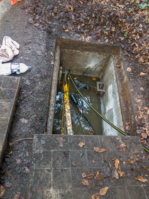
There was no fibre optics running to Owslebury telephone exchange, and internet backhaul was provided via an SHF radio link to Winchester. Beginning in August 2017 Openreach began unearthing the very old manhole covers running from Hazeley Road via Mare Lane and Whites Hill to Owslebury telephone exchange. Fibre optic cables were already present in Hazeley Road and it was intended to run them to the Owslebury exchange. However, collapsed ducts were found and it was necessary to arrange the closure of Mare Lane and Whites Hill. This took six months! In January 2018 subcontractors Morrison Utility Services were employed first to install monobore subduct tubing, and then to blow fibres through it. At last the exchange was connected to the outside world by fibre!
Meanwhile Openreach had reconfigured the large number of Exchange Only lines in Main Road and its offshoots to be serviced via a new cabinet installed directly outside the telephone exchange. This cabinet was numbered 4, despite there being, as far as I know, no cabinet numbered 3. Owslebury cabinet 4 went live on March 1st 2018, offering VDSL speeds to most of the village.
 Map © Crown Copyright")
- Grid Square
- SU5024, 10 images (more nearby 🔍)
- Photographer
- Peter Facey (more nearby)
- Date Taken
- Tuesday, 30 January, 2018 (more nearby)
- Submitted
- Sunday, 18 March, 2018
- Subject Location
-
OSGB36:
 SU 5060 2450 [10m precision]
WGS84: 51:1.0594N 1:16.8005W - Camera Location
-
OSGB36: SU 5060 2450
- View Direction
- NORTH (about 0 degrees)