2018
SK4067 : Grassmoor Country Park (Grassmoor Lagoons)
taken 6 years ago, near to Temple Normanton, Derbyshire, England
This is 1 of 7 images, with title Grassmoor Country Park (Grassmoor Lagoons) in this square
Grassmoor Country Park (Grassmoor Lagoons)
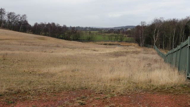
This north-westerly facing photograph was taken inside an area of land referred to as the Grassmoor Lagoons. It was taken when a group from the 'Friends of Grassmoor Country Park' were invited to examine the remediation work carried out thus far. I was fortunate enough to be invited along by a member of the group.
The photograph is looking toward an area of developing marsh land and, beyond the fence, the Grassmoor Golf Centre. The red material in the foreground is burnt shale Link
Grassmoor Country Park occupies much of the site of a colliery and training centre that closed between 1967 and 1971 Link
When the coking plant closed in 1993 Derbyshire County Council inherited the site and in 2010 work began to clear the contaminated land Link
For a photograph taken from a track leading down toward the marsh and looking back across the site, click here SK4067 : Grassmoor Country Park (Grassmoor Lagoons).
For a photograph showing the developing marsh, click here:- SK4067 : Grassmoor Country Park (Grassmoor Lagoons).
For a photograph that shows a contaminated surface area, click here:- SK4067 : Grassmoor Country Park (Grassmoor Lagoons).
For a photograph taken a few metres behind the viewpoint and looking in the opposite direction, click here SK4067 : Grassmoor Country Park (Grassmoor Lagoons).
For a photograph taken a few metres to the right on the other side of the fence, click here SK4167 : Grassmoor Country Park.
- - -
Note that although the remediation work to remove the lagoons was completed in 2015 the OS map still showed them in situ in March 2018.
 Map © Crown Copyright")
TIP: Click the map for more Large scale mapping
- Grid Square
- SK4067, 38 images (more nearby 🔍)
- Photographer
- Alan Walker (more nearby)
- Date Taken
- Wednesday, 21 February, 2018 (more nearby)
- Submitted
- Tuesday, 20 March, 2018
- Subject Location
-
OSGB36:
 SK 4084 6796 [10m precision]
WGS84: 53:12.4288N 1:23.3995W - Camera Location
-
OSGB36: SK 4094 6779
- View Direction
- North-northwest (about 337 degrees)