2013
SP4678 : Oxford Canal south of Easenhall in Warwickshire
taken 11 years ago, near to Easenhall, Warwickshire, England
This is 1 of 2 images, with title Oxford Canal south of Easenhall in Warwickshire in this square
Oxford Canal south of Easenhall in Warwickshire
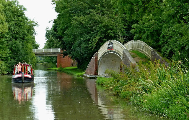
This view of the Oxford Canal is south-east of Cathiron Spinneys Bridge, No 38.
Off to the right is Brinklow Marina. The iron bridge, made at the Horseley Iron Works in Tipton carries the Oxford Canal Main Line towpath across the entrance to the former Fennis Field Arm, which itself was part of the original meandering Oxford Canal prior to the 1827-1834 upgrade.
Off to the right is Brinklow Marina. The iron bridge, made at the Horseley Iron Works in Tipton carries the Oxford Canal Main Line towpath across the entrance to the former Fennis Field Arm, which itself was part of the original meandering Oxford Canal prior to the 1827-1834 upgrade.
 Map © Crown Copyright")
TIP: Click the map for more Large scale mapping
- Grid Square
- SP4678, 88 images (more nearby 🔍)
- Photographer
- Roger D Kidd (more nearby)
- Date Taken
- Tuesday, 20 August, 2013 (more nearby)
- Submitted
- Friday, 6 April, 2018
- Subject Location
-
OSGB36:
 SP 4623 7853 [10m precision]
WGS84: 52:24.1701N 1:19.3149W - Camera Location
-
OSGB36: SP 4622 7855
- View Direction
- South-southeast (about 157 degrees)