SJ8415 : Rye Hill Cutting Bridge near Little Onn, Staffordshire
taken 6 years ago, near to Church Eaton, Staffordshire, England
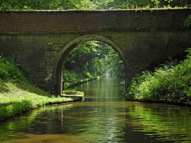
When the canals (or railways) were built in the 18th and 19th centuries, they were often routed in such a way that farmers and other landowners had their land bisected, so bridges had to be provided to allow access to fields on both sides of the canal. These bridges are frequently referred to as accommodation bridges, and however solid and well constructed, often don't lead anywhere except from one field to another.
The Shropshire Union Canal (from Autherley to Nantwich) was engineered by Thomas Telford and opened in 1835. There are long straight sections of this canal which required either embankments or cuttings to avoid the need for locks. Although this was a more difficult procedure, the end route was shorter and the progress for horse drawn working boats could be maintained with (hopefully) no stoppages. The canal (formerly the Birmingham and Liverpool Junction Canal) was opened at a time when railways were making serious inroads into the canal companies' businesses.
The current Shroppie north of Nantwich was formerly the Chester Canal, opened in 1779, and has wider locks and bridges. Boats up to nine feet in beam can still navigate this section; Telford's canal accommodates only narrowboats up to seven feet in beam.
 Map © Crown Copyright")
- Grid Square
- SJ8415, 64 images (more nearby 🔍)
- Photographer
- Roger D Kidd (more nearby)
- Date Taken
- Saturday, 9 June, 2018 (more nearby)
- Submitted
- Tuesday, 19 June, 2018
- Subject Location
-
OSGB36:
 SJ 8454 1568 [10m precision]
WGS84: 52:44.3116N 2:13.8251W - Camera Location
-
OSGB36: SJ 8453 1572
- View Direction
- South-southeast (about 157 degrees)