HY1700 : Old Man of Hoy
taken 6 years ago, 3 km from Moorfea, Hoy, Orkney Islands, Scotland
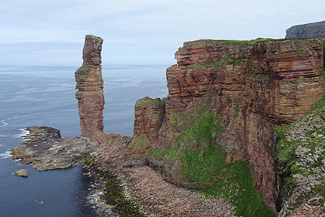
The Old Man of Hoy is a sea stack, at 137 metres one of the tallest, if not the tallest, in Britain.
It is composed of strata of the Upper Stromness Flagstone Formation of Old Red Sandstone, and stands on a base of basalt lava.
It is not mentioned in 'Orkneyinga Saga, and maps until the mid-18th century show a headland but no stack, so it is probably not more thaan 250 years old, even though the sandstone that makes it up is around 400 million years old.
In 1815 William Daniell made a drawing of it that shows a much thicker column with two legs separated by an arch. See Link
At some time during the 19th century one leg and the part of the stack above it collapsed, and by the time the Ordnance Survey got round to surveying Hoy for the first edition of the six-inch map, they recorded it as a stack as it is now.
A new crack has developed in the stack since 1992, which will result in the top collapsing. It is inevitable that the whole thing will collapse in due course.
The first recorded climb of the Old Man was in 1966, and the following year a repeat of that climb was televised. The stack regularly attracts experienced or foolhardy climbers.
The youngest person to climb it was Edward Mills, who reached the top on 8 June 2018 to raise money for a cancer charity. See Linkfor the full story.
.jpg)
 Map © Crown Copyright")
- Grid Square
- HY1700, 124 images (more nearby 🔍)
- Photographer
- Anne Burgess (more nearby)
- Date Taken
- Monday, 11 June, 2018 (more nearby)
- Submitted
- Thursday, 21 June, 2018
- Subject Location
-
OSGB36:
 HY 1761 0077 [10m precision]
WGS84: 58:53.1807N 3:25.8665W - Camera Location
-
OSGB36: HY 1778 0036
- View Direction
- North-northwest (about 337 degrees)