2018
TL8425 : The Iron Bridge in Marks Hall Park
taken 6 years ago, 3 km from Pattiswick, Essex, England
This is 1 of 2 images, with title The Iron Bridge in Marks Hall Park in this square
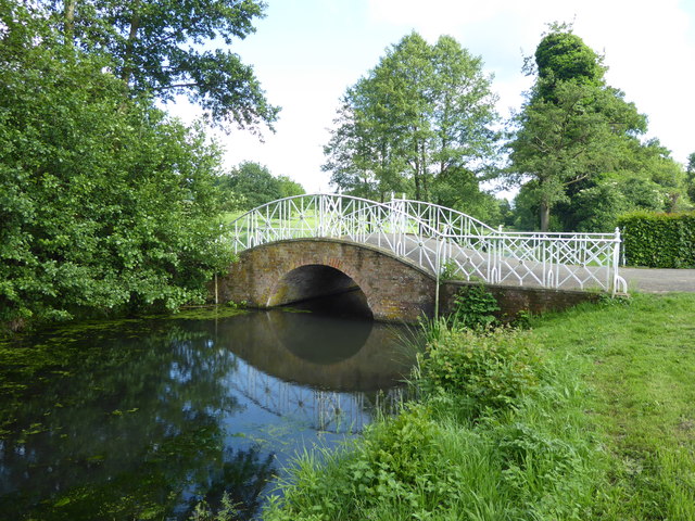
The Iron Bridge in Marks Hall Park
Marks Hall Estate was left to the nation in the will of Thomas Phillips Price in 1927. He died in 1932 leaving his widow a life interest in the Marks Hall Estate. Mrs Phillips Price survived him by 34 years and died on 18th November 1966 at which point the Estate reverted to the nation. In the intervening years, however, the house had been demolished, oaks had been felled and the gardens and deer park were overgrown. With the approval of HM Treasury the Thomas Phillips Price trust was established in 1971. The Estate is now a registered charity - see Link for more information.
Local legend suggests the lakes were dug by Cromwell's troops at the time of the Siege of Colchester in 1648. They were formed by damming the Robin Brook which is a tributary of the River Blackwater. The Iron Bridge spans the Robin Brook below the lakes. It was built at the turn of the 19th century, probably by Sir Filmar Honywood who carried out a lot of work in the gardens. It was extensively restored in 1992 and new cast iron work was produced at a local foundry to replace missing sections.
Local legend suggests the lakes were dug by Cromwell's troops at the time of the Siege of Colchester in 1648. They were formed by damming the Robin Brook which is a tributary of the River Blackwater. The Iron Bridge spans the Robin Brook below the lakes. It was built at the turn of the 19th century, probably by Sir Filmar Honywood who carried out a lot of work in the gardens. It was extensively restored in 1992 and new cast iron work was produced at a local foundry to replace missing sections.
 Map © Crown Copyright")
TIP: Click the map for more Large scale mapping
- Grid Square
- TL8425, 36 images (more nearby 🔍)
- Photographer
- Marathon (more nearby)
- Date Taken
- Saturday, 2 June, 2018 (more nearby)
- Submitted
- Thursday, 21 June, 2018
- Subject Location
-
OSGB36:
 TL 8400 2519 [10m precision]
WGS84: 51:53.6928N 0:40.3636E - Camera Location
-
OSGB36: TL 8399 2520
- View Direction
- South-southeast (about 157 degrees)